Giochi dell'Oca e di percorso
(by Luigi Ciompi & Adrian Seville)
(by Luigi Ciompi & Adrian Seville)
|
Giochi dell'Oca e di percorso
(by Luigi Ciompi & Adrian Seville) |
|
|
 |
Torna alla ricerca giochi (back to game search) |
 |
| Nouveau (Le) Jeu de Geographie des Nations -The New Game of Geography of Nations | ||
 |
Versione stampabile
 |
Invia una segnalazione

|
   |
primo autore: | Anonimo |
| secondo autore: | Desmartins Charles-François-Henry, Brissart Pierre | |
| anno: | 1675 | |
| luogo: |
Francia-Parigi |
|
| periodo: | XVII secolo (4°/4) | |
| percorso: | Gioco con i dadi | |
| materiale: | carta (paper) (papier) | |
| dimensioni: | 900X685 (537X530) | |
| stampa: | Acquaforte (taille-douce) (ecthing) | |
| luogo acquisto: | ||
| data acquisto: | ||
| dimensioni confezione: | ||
| numero caselle: | 8 | |
| categoria: | Geografia | |
| tipo di gioco: | Gioco con i dadi | |
| editore: | Jaillot Alexis-Hubert | |
| stampatore: | Jaillot Alexis-Hubert, joignant les grands Augustins aux deux Globes | |
| proprietario: | Collezione Rothschild | |
| autore delle foto: | Waddesdon The Rothschild Collection (The National Trust) | |
| numero di catalogo: | 1164 | |
| descrizione: |
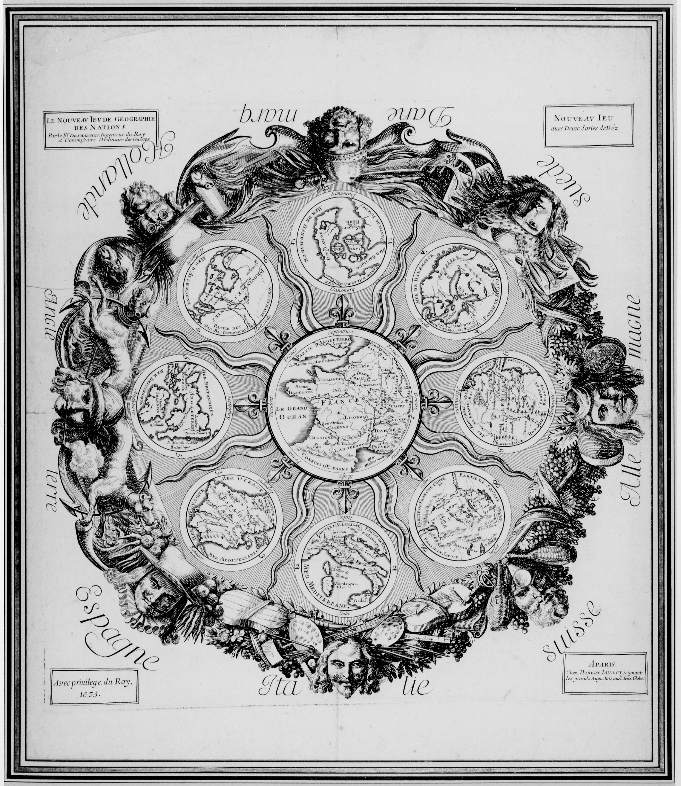
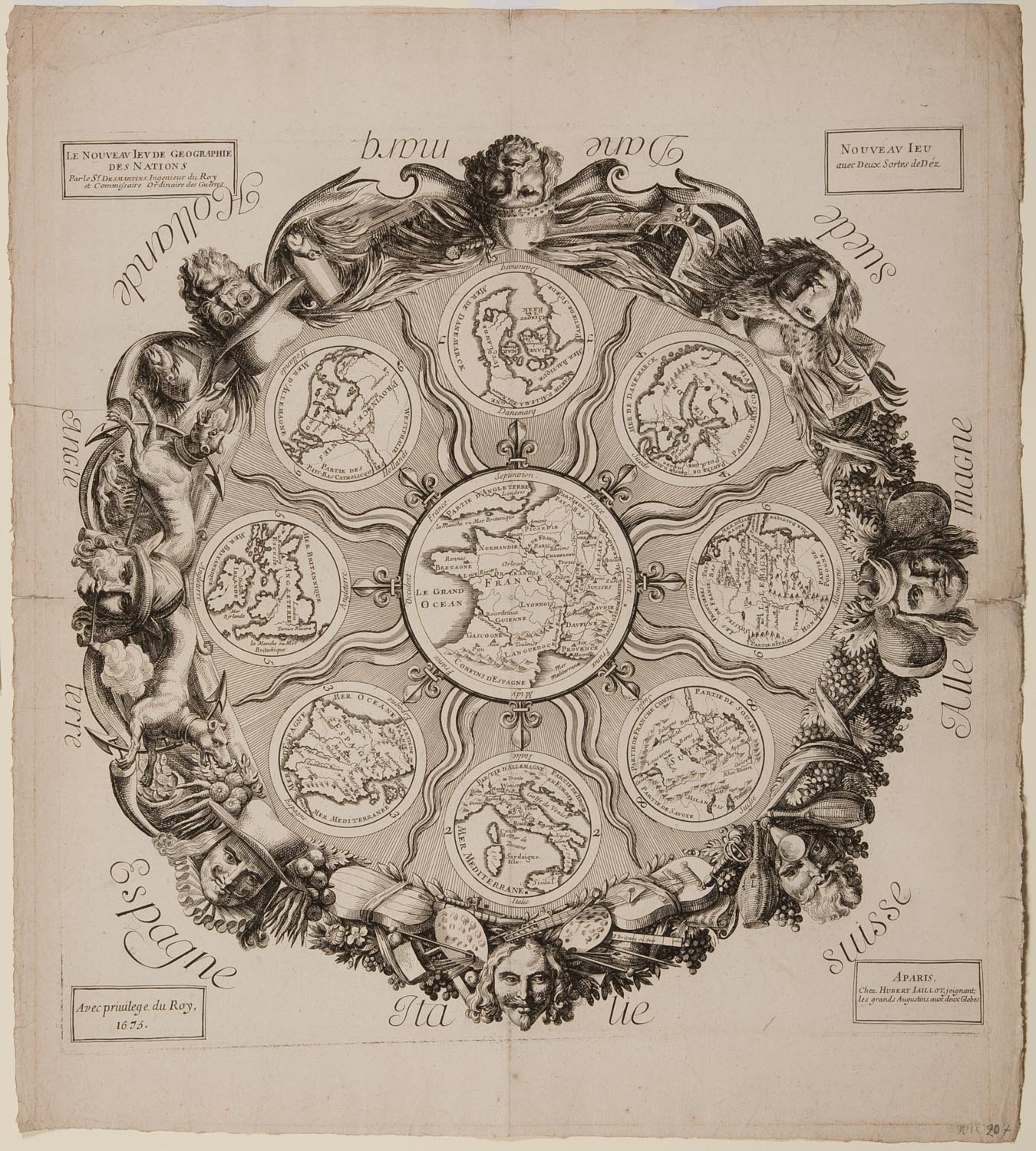
Gioco con i dadi con otto caselle circolari ed una centrale rappresentante la Francia. REGOLE: non riportate sul tavoliere. CASELLE: con didascalie (carte geografiche). REFERENZA 1 This game consists of a circular map of France surrounded by smaller circular maps of (clockwise from the top) Denmark, Sweden, Germany, Switzerland, Italy, Spain, England, and Holland. In a box top left, the title is given and below it the inventor is stated to be Sr. Desmartins, Ingenieur du Roy et Commissaire Ordinaire des Guerres. Opposite right is a box stating simply: Nouveau Jeu avec Deux Sortes des Dez. The game is not listed in DAllemagne. Thierry Depaulis (correspondence, 30 July 2009), notes that there is a very rare rulebook: Le jeu des nations. A Paris 1674, no publisher. The title-page says 1674 but the colophon is dated 1675. The Extrait du privilège du Roy gives the exclusive right of publication au Sieur D., en considération des [sic] ses services. At the end of the book is A Paris, chez Hubert Jaillot, joignant les Grands Augustins, au bout du Pont-Neuf, au deux Globes. The book contains also Le jeu du Tourtable (or Touretable). There is a copy preserved in the United States Playing-Card Companys Playing-Card Museum [see Hargrave, 1930 and Zollinger, 1996]. Depaulis (1994) identifies the author as C.H.F. Desmartins, ingénieur du Roy et commissaire ordinaire des guerres of Louis XIV who invented several games, including a sort of military billiards in 1673. In 1676, Desmartins published Instructions pour un jeu de cartes nouvellement inventé, avec un nouveau jeu de touretable dedicated to the Duc du Maine, colonel général des Suisses (Paris: s.n. (ruë du Bouloy, près Saint Honoré, à lhostel du Saint Esprit), M. DC. LXXVI): that game is based on European infantry and requires 52 special cards. The present authors have not seen the rulebook for the Jeu des Nations and hence the playing principles of the Waddesdon game cannot be given here. (Plock, Phillippa - Seville Adrian) REFERENZA 2 "The New Game of Geography of Nations (Le Nouveau Jeu de Geographie des Nations)",1675. Charles-Francois-Henry Desmartins (active c. 1675), engraved by Pierre Brissart (d.1682), published by Alexis-Hubert Jaillot (b. c.1632, d.1712); etching and engraving. Waddesdon Manor, The Rothschild Collection (Rothschild Family Trust). This game about Europe combines maps of the individual countries as well as personifications of their perceived national characteristics. Since this is a French game, France occupies the centre and is exempt from humorous characterisation. The rules are not included on the game itself but we know that it was to be played with two sorts of dice. The publisher, Alexis-Hubert Jaillot, was also a sculptor and cartographer. He produced the L'Atlas Nouveau in 1681, which led to him being named Geographer to the King in 1686. (Jacobs Rachel) REFERENZA 3 (Découverte dune rareté de la carte à jouer du XVIIe siècle français) (Thierry Depaulis et Maxime Préaud) REFERENZA 4 Det Kongelige Bibliotek. Copenaghen, Danimarca. Exhibitions - "Playing, Learning, Flirting: Printed Board Games from 18th-Century France". Catalogue exhibition of French eighteenth-century Board Games, 28 March 28 October 2012, Waddesdon Manor, The Rothschild Collection (Rothschild Family Trust). Rachel Jacobs, Curator. |
|
| bibliografia: |
1) SEVILLE, Adrian:"The Game of Goose: and its influence on cartographical race games." In: Journal of the International Map Collectors' Society, Winter 2008 n°115, 2008. 2) PLOCK, Phillippa - SEVILLE, Adrian:"The Rothschild Collection of printed board games at Waddesdon Manor", in XIIIth Board Game Studies Colloquium, Paris, 14-17 April 2010. 3) SEVILLE, Adrian: "Geographical Pastimes. Two Early English Map Games." In: "IMCOS Journal" n° 124, Spring 2011, (pages 43-46). 4) JACOBS, Rachel: "Playing, Learning, Flirting: Printed Board Games from 18th-Century France". Catalogue exhibition of French eighteenth-century Board Games, 28 March 28 October 2012, Waddesdon Manor, The Rothschild Collection (Rothschild Family Trust). Rachel Jacobs, Curator. 5) DEPAULIS, Thierry - PREAUD, Maxime: "Découverte dune rareté de la carte à jouer du XVIIe siècle français."), in "Nouvelles de l'estampe", 254/2016. 6) SEVILLE, Adrian - DEPAULIS, Thierry - BEKKERING, Geert H.: Playing with Maps: Cartographic Games in Western Culture. Brill Research Perspectives, Leiden-Boston, pag. 88, 2023. |
|
| Playing with Maps: Cartographic Games in Western Culture (Adrian Seville) | ||
| Accession N°2669.1.7 Waddesdon-The Rothschild Collection | ||
Vai alla ricerca giochi Vai all'elenco autori