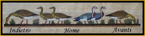
Giochi dell'Oca e di percorso
(by Luigi Ciompi & Adrian Seville)
(by Luigi Ciompi & Adrian Seville)
|
Giochi dell'Oca e di percorso
(by Luigi Ciompi & Adrian Seville) |
|
|
 |
Torna alla ricerca giochi (back to game search) |
 |
| Royal (The) Geographical Pastime or the complete Tour of Europe | ||
| For Thomas Jefferys Geographer of the King | ||
 |
Versione stampabile
 |
Invia una segnalazione

|
  |
primo autore: | Anonimo |
| secondo autore: | Jefferys Thomas | |
| anno: | 1768 | |
| luogo: |
Inghilterra-Londra |
|
| periodo: | XVIII secolo (3°/4) | |
| percorso: | Percorso di 103 caselle numerate | |
| materiale: | carta incollata su tela (engraving on paper with linen backing) | |
| dimensioni: | 495X660 | |
| stampa: | Cromolitografia | |
| luogo acquisto: | ||
| data acquisto: | ||
| dimensioni confezione: | ||
| numero caselle: | 103 | |
| categoria: | Geografia | |
| tipo di gioco: | Gioco di percorso | |
| editore: | Jefferys Thomas Geographer to the King | |
| stampatore: | Printed & Sold by W.m Faden Charing Cross | |
| proprietario: | Collezione A. Seville | |
| autore delle foto: | A. Seville | |
| numero di catalogo: | 1310 | |
| descrizione: |
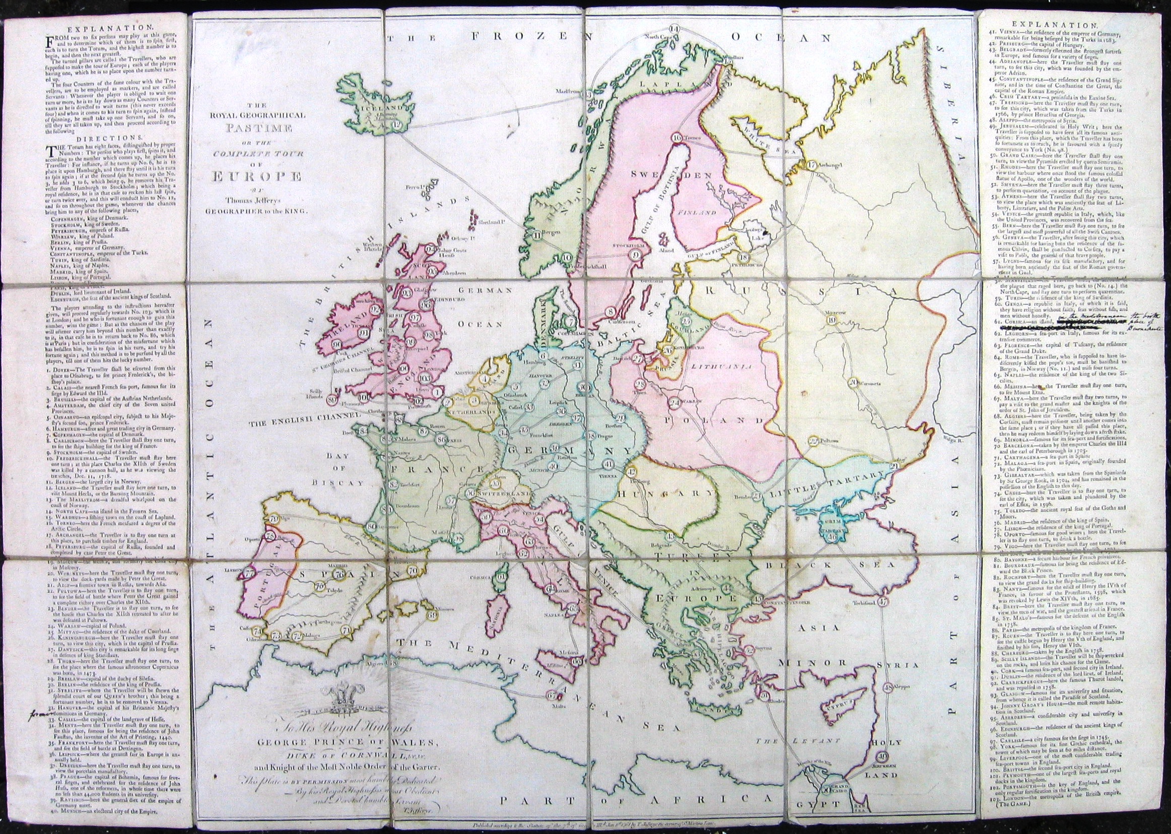
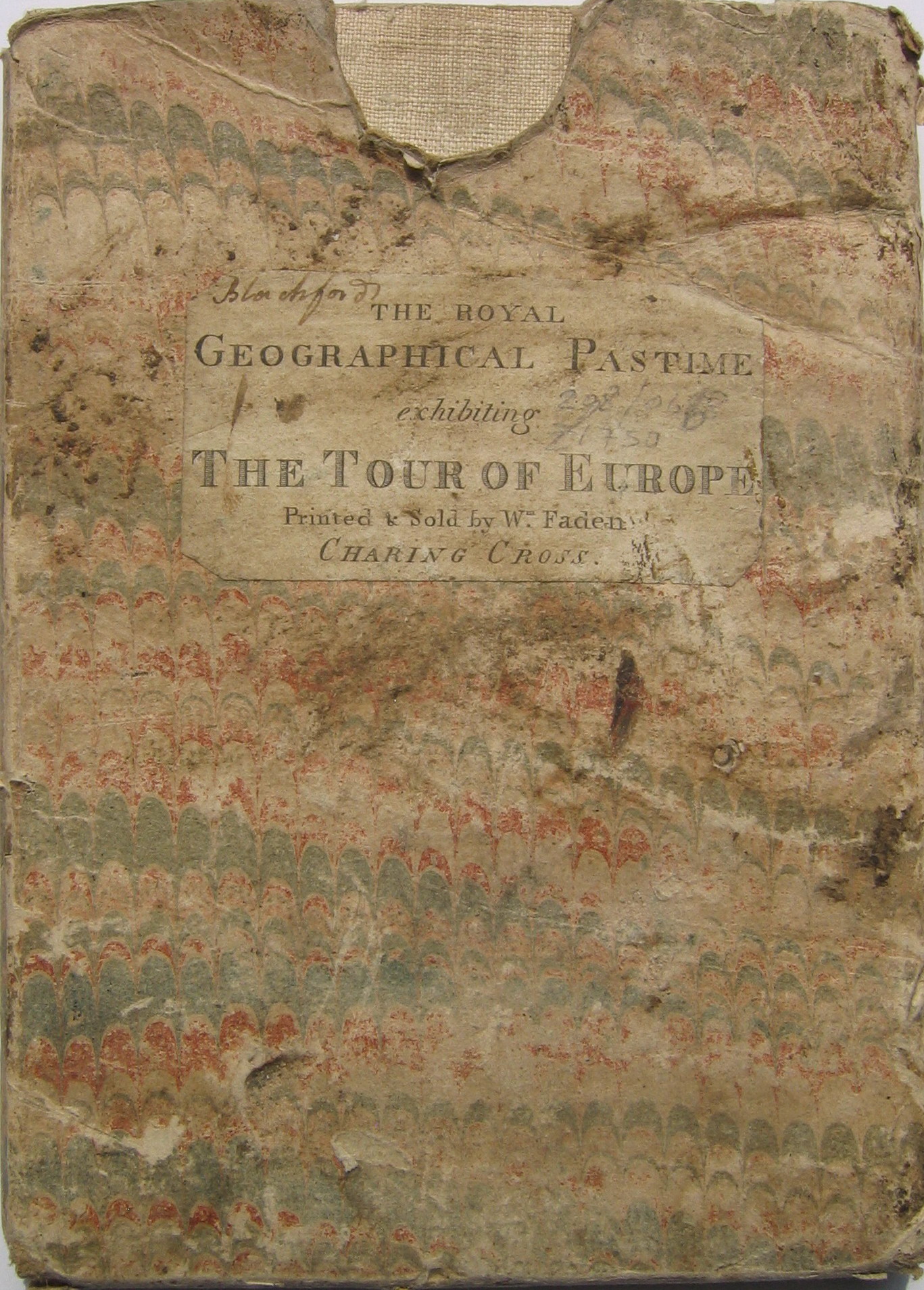
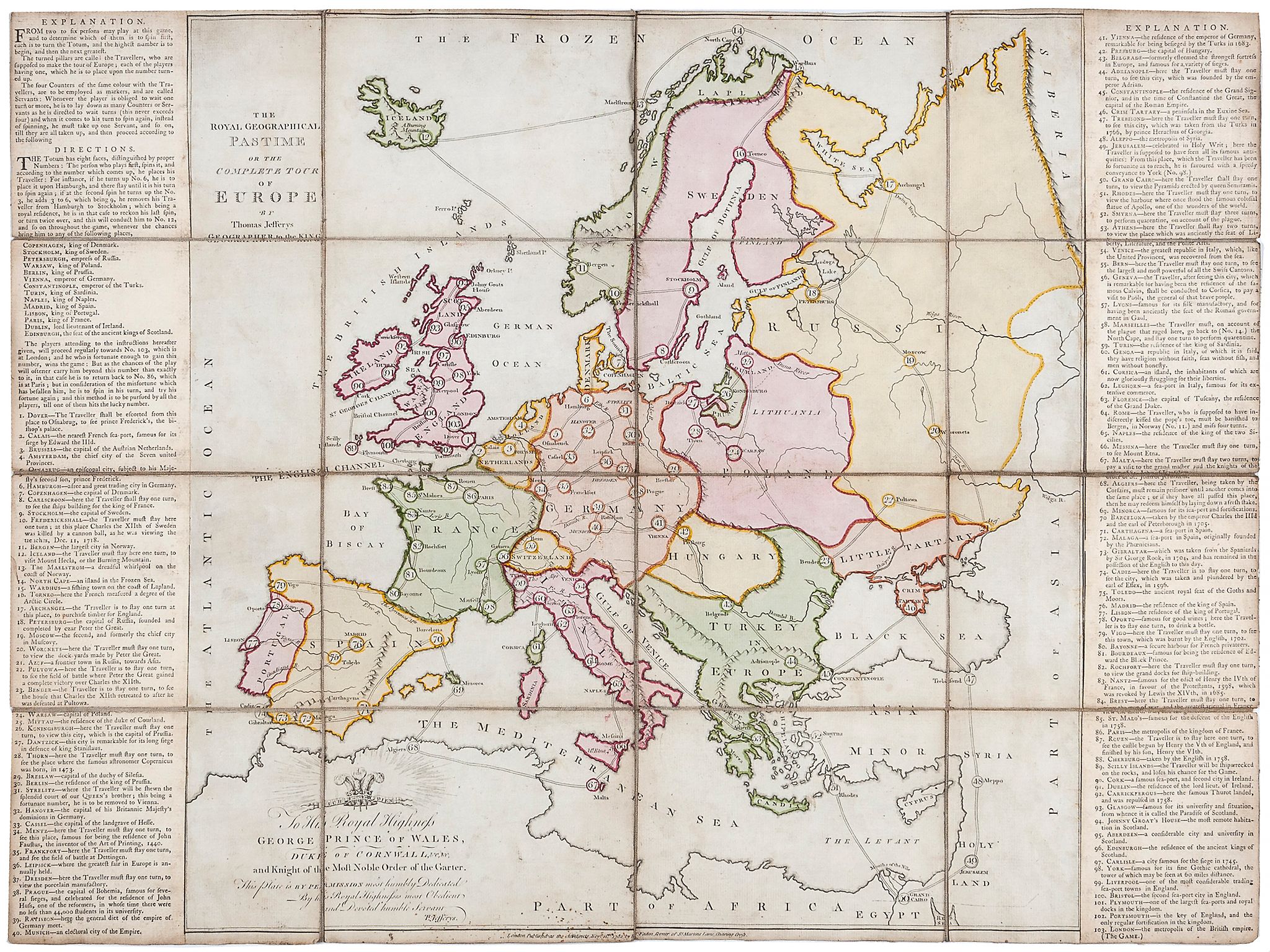
Gioco di 103 caselle numerate distribuite sulla carta dell'Europa: partenza da Dover e arrivo a Londra. REGOLE: ai lati. CASELLE: mute. REFERENZA 1 Jefferys (Thomas). The Royal Geographical Pastime or the Complete Tour of Europe, a game through 103 cities in Europe, starting in Dover and ending in London. Explanation text panels to each side, engraved map with original handc-colouring, 495 x 660mm., dissected and linen-backed, slight surface dirt, lacking slipcase, 2nd state, William Faden, 1782. REFERENZA 2 Game 30: Complete Tour of Europe The Royal Geographical Pastime or Complete Tour of Europe. London: Thomas Jefferys, Geographer to the King, 1768. Copper engraving with original hand color, 50 x 69 cm., dissected and laid on linen in 3 x 6 panels. Ref: Ciompi/Seville 1310. This is the second known British educational race game, the earliest being A Journey through Europe, or the Play of Geography, invented by John Jefferys in 1759. The present exhibit follows the earlier game in concept but with detailed differences. It is dated at the foot of the engraved plate: published according to the 7th of George IIId 1st January 1768 by T Jefferys corner of St Martins Lane. The dedication is to George Prince of Wales, Duke of Cornwall and Knight of the Most Honourable Order of the Garter. An advertisement for the game appears in the January 2729, 1768 issue (no. 1648) of Lloyd's Evening Post: This Day is published, Price 8s. Dedicated by Permission, to his Royal Highness the Prince of WALES, THE ROYAL GEOGRAPHICAL PASTIME; or, The COMPLETE TOUR of EUROPE. By T. JEFFERYS, Geographer to the King. Sold by T. Jefferys, the Corner of St. Martin's-lane, in the Strand. The game sheet begins with a description of the mode of play, which is of interest in that it clearly states the playing equipment needed: From two to six persons may play this game, and to determine which of them is to spin first, each is to turn the Totum, and the highest number is to begin, and then the next greatest. The turned pillars are called Travellers, who are supposed to make the tour of Europe; each of the players having one, which he is to place on the number turned up. The four counters of the same colour with the Travellers, are to be employed as markers, and are called Servants. Whenever a player is obliged to wait one turn or more, he is to lay down as many Counters or Servants as he is directed to wait turns (this never exceeds four), and when it comes to his turn to spin again, instead of spinning, he is to take up one Servant, and so on, till they are all taken up ... The Totum has eight faces, with proper numbers ... In English domestic circles, there was a prejudice against using dice and dice boxes, which were associated with gambling. Instead, the Totum (a sort of small top, here with eight sides, later called the Teetotum) was substituted. The turned pillars were wooden pawns, each painted in a different color. The game shares with its predecessor the use of a numbered track of cities. Here the track goes from Dover (space 1) to London (space 103) via the countries of Europe with an extension to the Holy Land and Egypt. Both games share a link with Goose, the cities which are royal residences being treated as throw-doubling spaces. These include Dublin (lord lieutenant of Ireland), Edinburgh (seat of the ancient kings of Scotland, Petersburgh (empress of Russia), Vienna (emperor of Germany) and Constantinople (emperor of the Turks), as well as the capital cities housing European kings. The games also share anti-Catholic prejudice, as here: Space 64 Rome - the Traveller, who is supposed to have indiscreetly kissed the popes toe, must be banished to Bergen in Norway (No. 11) and miss four turns. Certain of the hazard spaces also recall Goose: Space 68 Algiers here the Traveller, being taken prisoner by the Corsairs, must remain prisoner until another comes into the same place; or, if they have all passed this place, then he may redeem himself by laying down a fresh stake. However, unlike the death rule in Goose, here there is no second chance: Space 89 Scilly Islands the Traveller will be shipwrecked on the rocks and loses his chance of game. There are numerous references to the Hanoverian connections, though a later hand has added the word former to: Space 30 Hanover the capital of His Britannic Majestys Dominions in Germany. The same hand has amended Space 61 Corsica to make it read: an island in the Mediterranean, the birthplace of Buonaparte. As well as international politics, there is much information about trade: Space 17 Archangel the Traveller is to stay one turn at this place, to purchase timber for England. The game is entirely playable and the information is conveyed succinctly and without overt moralizing, even if its prejudices are of its time. (Adrian Seville) Exhibitions: - "The Royal Game of the Goose four hundred years of printed Board Games". Exhibition at the Grolier Club, February 23 - May 14, 2016 (Prof. Adrian Seville). |
|
| bibliografia: |
1) WHITEHAUSE, F.R.B.: "Table Games of Georgian and Victorian Days", London, Peter Garnett, 1951. 2) GOODFELLOW, Caroline: "A Collector's Guide to Games and Puzzles". Secaucus, New Jersey, Chartwell Books-London, Quintet Publishing Limited 1991. 3) GOODFELLOW, Caroline: "The Development of the English Board Game, 1770-1850", in Board Games Studies 1, 1998. 4) GOODFELLOW, Caroline: "Jeux de société. Le guide du collectionneur des jeux de société depuis le XVIIIe siècle jusquà nos jours", (Edizione francese) Carrousel MS, 2001. 5) SEVILLE, Adrian: "The Game of Goose: and its influence on cartographical race games" Journal of the International Map Collectors' Society, Winter 2008 N°115 2008. 6) SEVILLE, Adrian: "The geographical Jeux de l'Oie of Europe." In "Belgeo" 2008 3-4 2008. 7) GOODFELLOW, Caroline: "How We Played: Games From Childhood Past", History Press, 2012. 8) QUINN, Brian - CARTWRIGHT, William: "Geographic Board Games". Geospatial Science Research 3. School of Mathematical and Geospatial Science, RMIT University, Australia. December 2014. 9) SEVILLE, Adrian: "The Royal Game of the Goose four hundred years of printed Board Games". Catalogue of an Exhibition at the Grolier Club, February 23 - May 14, 2016. 10) LIMAN, Ellen: "Georgian and Victorian Board Games: The Liman Collection", Pointed Leaf Press, 2017. 11) NORCIA, Megan A.: "Gaming Empire in Children's British Board Games, 1836-1860". Studies in Childhood, 1700 to the Present. Routledge, 2019. 12) SEVILLE, Adrian: "L'arte dei giochi da tavolo. Oltre un secolo di storia e divertimento dalla fine del Settecento all'inizio del Novecento." Edizioni White Star, 2019. 13) PARLAK, Omer Fatih: "Seafearing through the Perspective of Historic Board Games", in DGSM, Köllen Druck+Verlag, Bonn 2020. |
|
| Geographical Pastimes. Two early English map games (A. Seville) | ||
| Geographical Games. "Table Games of Georgian and Victorian Days". (Francis Reginald Beaman, Whitehause) | ||
Vai alla ricerca giochi Vai all'elenco autori