Giochi dell'Oca e di percorso
(by Luigi Ciompi & Adrian Seville)
(by Luigi Ciompi & Adrian Seville)
|
Giochi dell'Oca e di percorso
(by Luigi Ciompi & Adrian Seville) |
|
|
 |
Torna alla ricerca giochi (back to game search) |
 |
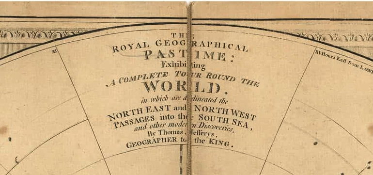
| Royal (The) Geographical Pastime: Exhibiting A Complete Tour Round the World in which are delineated the North East and North West Passages in the South Sea and other modern Discoveries By Jefferys Thomas Geographer to the King. | ||
 |
Versione stampabile
 |
Invia una segnalazione

|
         |
primo autore: | Anonimo |
| secondo autore: | Jefferys Thomas | |
| anno: | 1770 | |
| luogo: |
Inghilterra-Londra |
|
| periodo: | XVIII secolo (3°/4) | |
| percorso: | Percorso di 103 caselle numerate | |
| materiale: | carta incollata su tela (engraving on paper with linen backing) | |
| dimensioni: | 500X700 | |
| stampa: | Litografia (litographie) (engraving) | |
| luogo acquisto: | ||
| data acquisto: | ||
| dimensioni confezione: | ||
| numero caselle: | 103 | |
| categoria: | Geografia | |
| tipo di gioco: | Gioco di percorso | |
| editore: | Published by Jefferys Thomas at the Corner of St Martin Lane | |
| stampatore: | Jefferys Thomas | |
| proprietario: | Collezione Privata | |
| autore delle foto: | Privato | |
| numero di catalogo: | 2348 | |
| descrizione: |
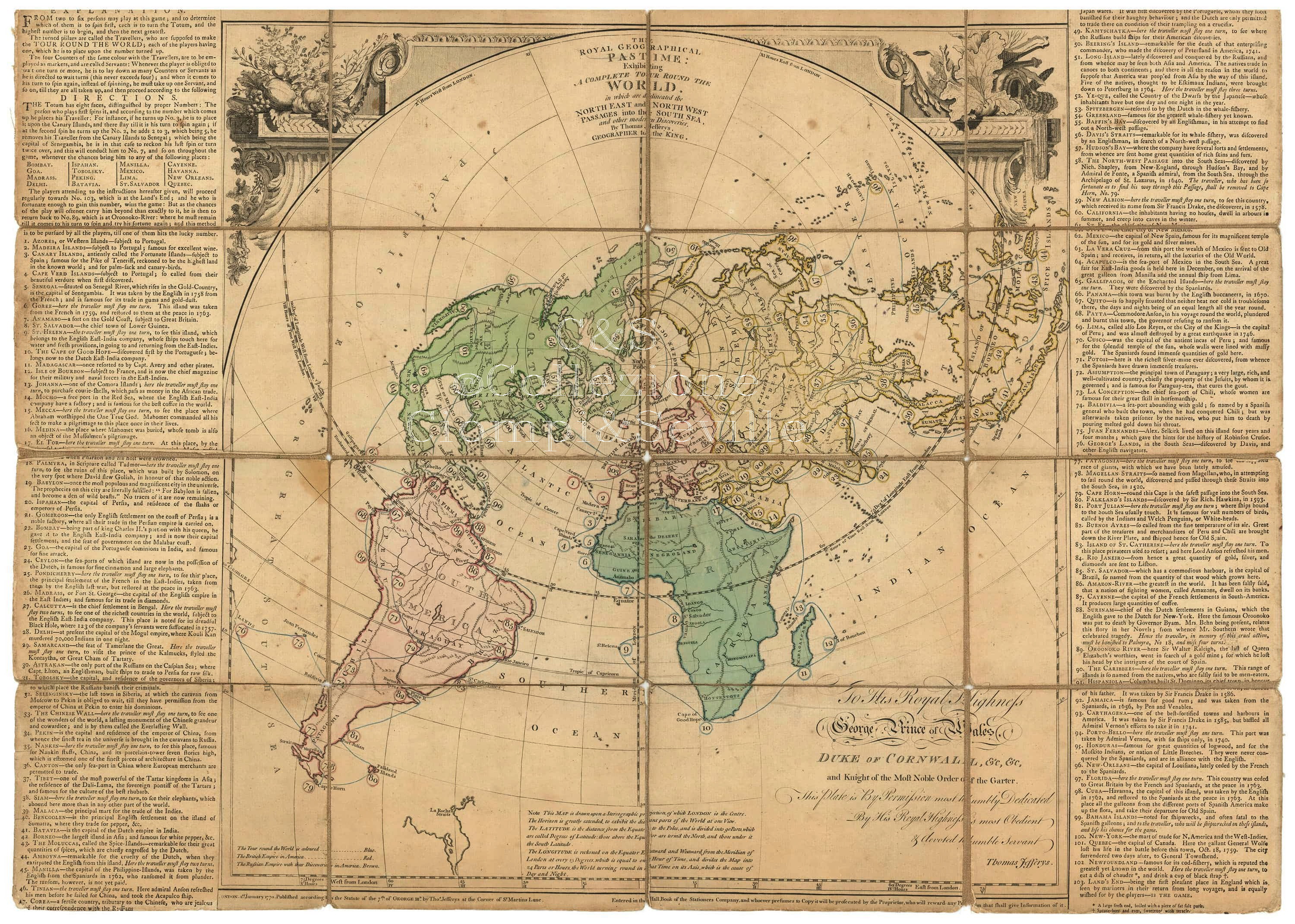
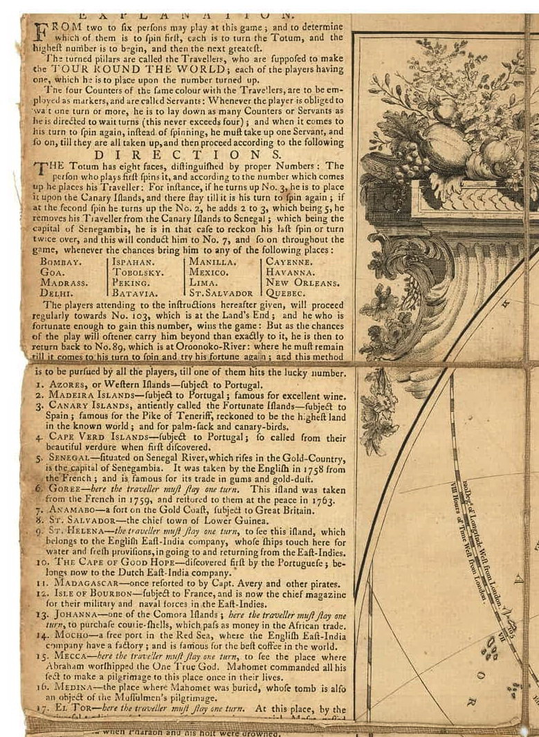
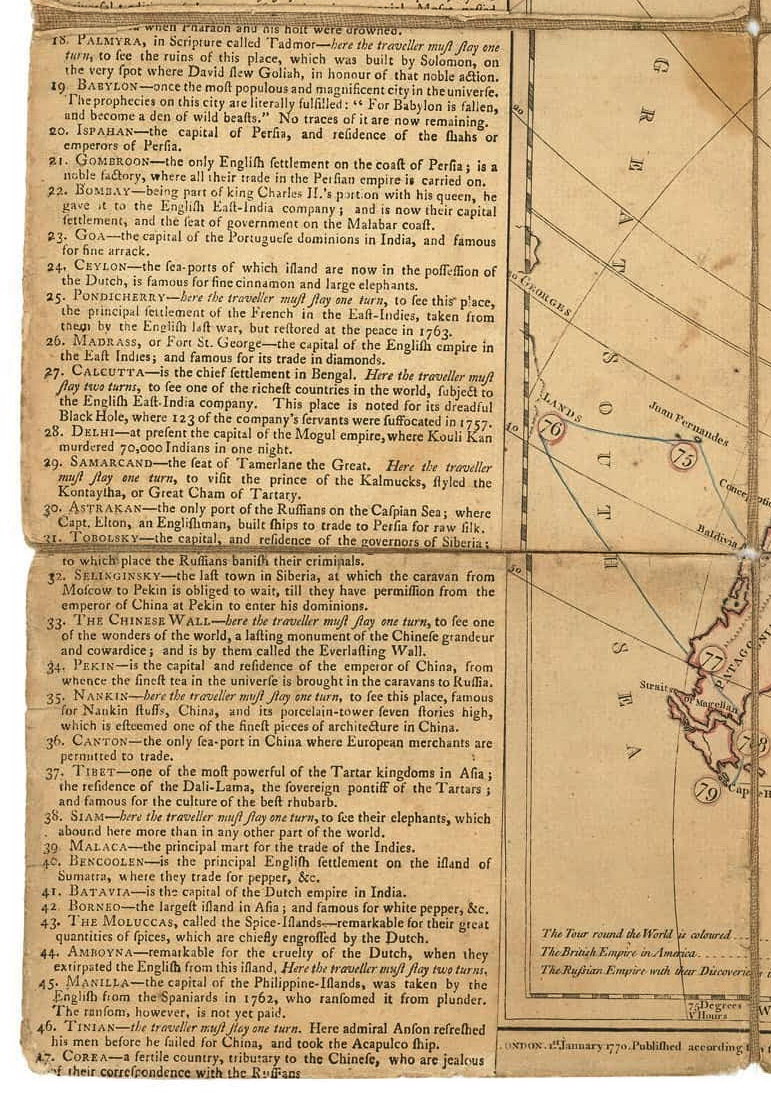
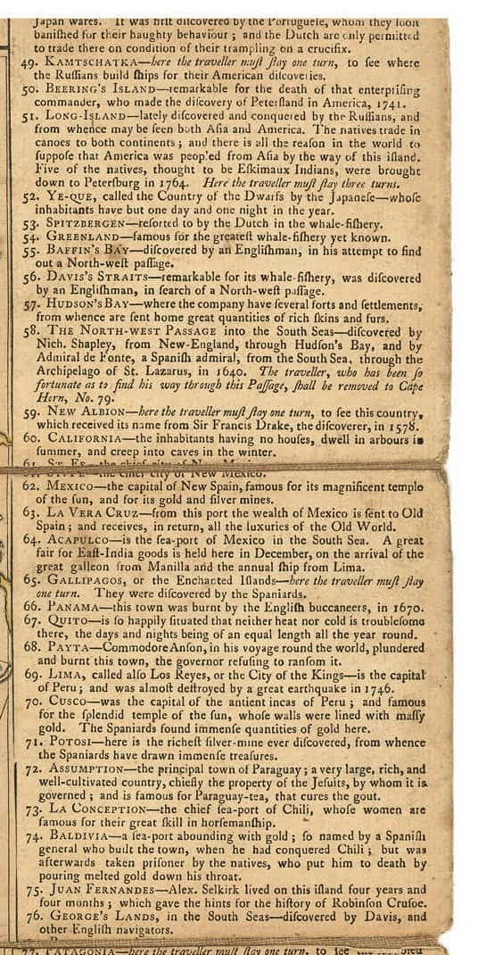
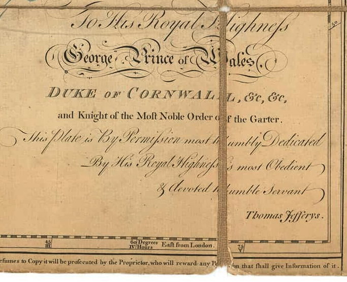
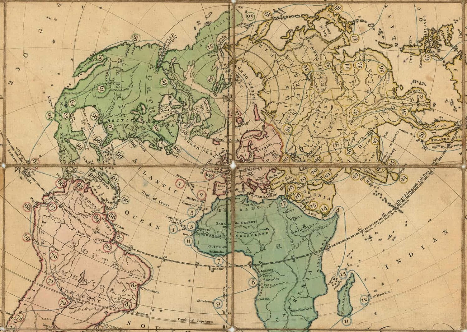
Gioco di 103 caselle numerate distribuite sulla carta del mondo. Partenza dalle Azzorre e arrivo a Land's End in Inghilterra. REGOLE: a destra e a sinistra sul tavoliere. CASELLE: mute. REFERENZA 1 Jefferys (Thomas). The Royal Geographical Pastime, Exhibiting a Complete Tour Round the World, a game through 103 points of interest around the world, starting in the Azores and ending at Land's End. Explanation text panels to each side, 2nd state with the dedication to the Prince of Wales, engraved map with original hand-colouring, 500 x 700mm., dissected and linen-backed. 1770. REFERENZA 2 The board consists of a world map on a stereographic projection and centered on London. The route of a circumnavigation is outlined in blue and passes through 103 points of interest numbered in sequence. Players take turns by rolling a totum and moving their game piece a corresponding distance along the sequence. The journey begins in the Azores - the first stop on many trans-Atlantic voyages of the time-and terminates at Lands End on the English coast. The board is flanked on either side by letterpress text panels explaining the games rules, describing the places visited and occasionally specifying penalties. Most of these involve the loss of a turn, though anyone unfortunate enough to land on the Bahamas (#99) will be shipwrecked on these islands, and lose his chance for the game. This is the second state of the game, with the added dedication to the Prince of Wales. Both states are extremely rare: I find no record of other examples having appeared on the market and only two examples held in institutions. References British Museum, Catalogue of Maps, World, p. 87 / 950 (22.) COPAC records a lone example of the first state held at the British Library (presumably one and the same as that listed in the British Museum catalog), while OCLC records one or possibly two examples, state indeterminate, also at the British Library. An example of state 2 is at Colonial Williamsburg and illustrated in Martin Bruckners Geographical Revolution, p. 182. OCLC #558043771 records what appears to be a 1993 facsimile, held at four American institutions. (Boston Rare Maps) |
|
| bibliografia: |
1) WHITEHAUSE, F.R.B.: "Table Games of Georgian and Victorian Days", London, Peter Garnett, 1951. 2) GOODFELLOW, Caroline: "A Collector's Guide to Games and Puzzles". Secaucus, New Jersey, Chartwell Books-London, Quintet Publishing Limited 1991. 3) GOODFELLOW, Caroline: "The Development of the English Board Game, 1770-1850", in Board Games Studies 1, 1998. 4) GOODFELLOW, Caroline: "Jeux de société. Le guide du collectionneur des jeux de société depuis le XVIIIe siècle jusquà nos jours", (Edizione francese) Carrousel MS, 2001. 5) SEVILLE, Adrian: "The Game of Goose: and its influence on cartographical race games" Journal of the International Map Collectors' Society, Winter 2008 N°115 2008. 6) SEVILLE, Adrian: "The geographical Jeux de l'Oie of Europe." In "Belgeo" 2008 3-4 2008. 7) GOODFELLOW, Caroline: "How We Played: Games From Childhood Past", History Press, 2012. 8) QUINN, Brian - CARTWRIGHT, William: "Geographic Board Games". Geospatial Science Research 3. School of Mathematical and Geospatial Science, RMIT University, Australia. December 2014. 9) SEVILLE, Adrian: "The Royal Game of the Goose four hundred years of printed Board Games". Catalogue of an Exhibition at the Grolier Club, February 23 - May 14, 2016. 10) LIMAN, Ellen: "Georgian and Victorian Board Games: The Liman Collection", Pointed Leaf Press, 2017. 11) NORCIA, Megan A.: "Gaming Empire in Children's British Board Games, 1836-1860". Studies in Childhood, 1700 to the Present. Routledge, 2019. 12) SEVILLE, Adrian: "L'arte dei giochi da tavolo. Oltre un secolo di storia e divertimento dalla fine del Settecento all'inizio del Novecento." Edizioni White Star, 2019. 13) LudoSophia: "Jeux Anciens de Planisphère et de Mappemonde - Ancient Games with World Map, 2019. |
|
| "The Development of the English Board Game", 1770-1850 (Caroline G. Goodfellow) | ||
| Geographical Games. "Table Games of Georgian and Victorian Days". (Francis Reginald Beaman, Whitehause) | ||
Vai alla ricerca giochi Vai all'elenco autori