Giochi dell'Oca e di percorso
(by Luigi Ciompi & Adrian Seville)
(by Luigi Ciompi & Adrian Seville)
|
Giochi dell'Oca e di percorso
(by Luigi Ciompi & Adrian Seville) |
|
|
 |
Torna alla ricerca giochi (back to game search) |
 |
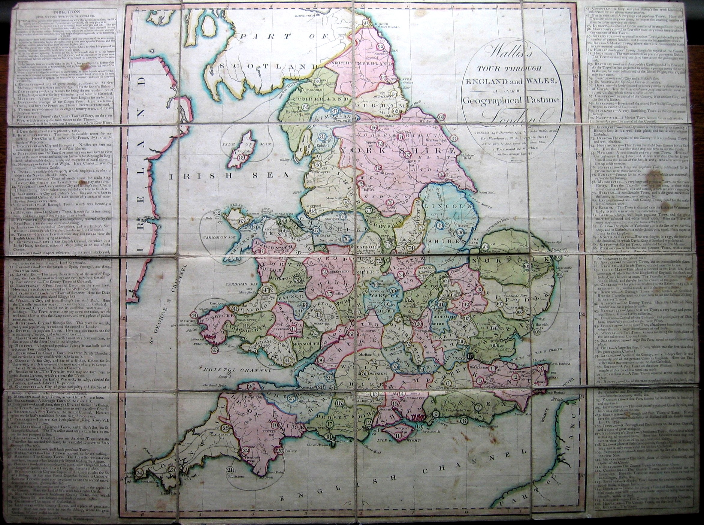
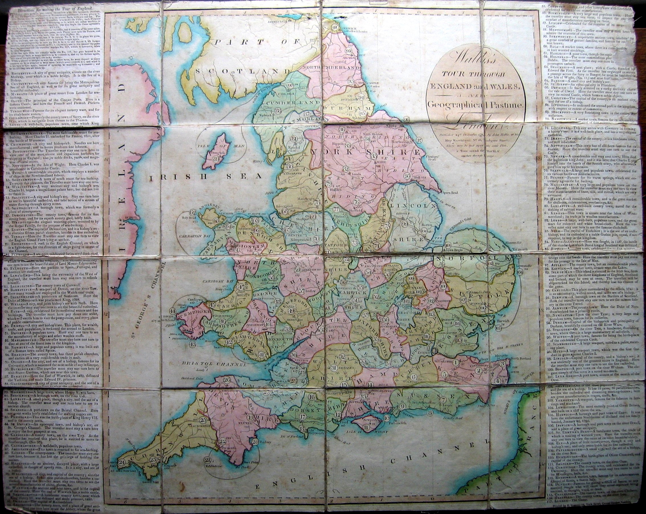
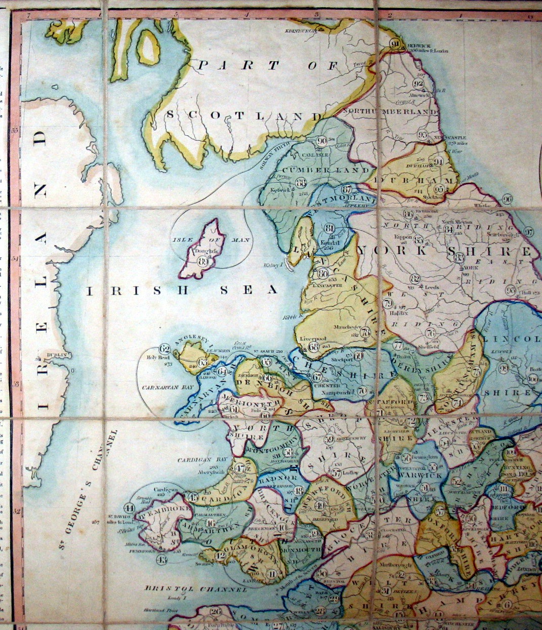
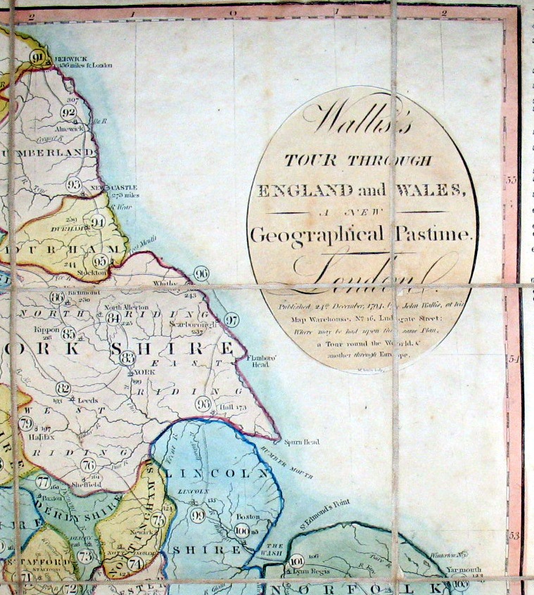
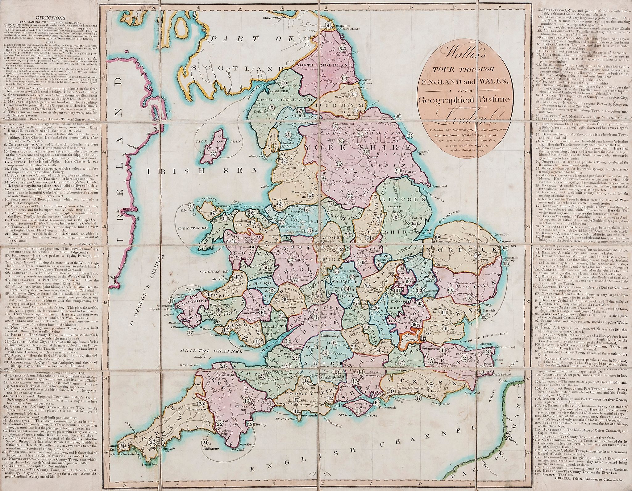
| Wallis's Tour through England and Wales. A New Geographical Pastime | ||
 |
Versione stampabile
 |
Invia una segnalazione

|
             |
primo autore: | Non indicato |
| secondo autore: | Wallis | |
| anno: | 1794 | |
| luogo: |
Inghilterra-Londra |
|
| periodo: | XVIII secolo (4°/4) | |
| percorso: | Percorso di 117 caselle numerate | |
| materiale: | carta incollata su tela (engraving on paper with linen backing) | |
| dimensioni: | 510X650 | |
| stampa: | Litografia (gravure) (engraving) | |
| luogo acquisto: | ||
| data acquisto: | ||
| dimensioni confezione: | ||
| numero caselle: | 117 | |
| categoria: | Geografia | |
| tipo di gioco: | Gioco di percorso | |
| editore: | Wallis John, 16 Ludgate Str.t | |
| stampatore: | Wallis, John | |
| proprietario: | Collezione A. Seville - E. C. | |
| autore delle foto: | A. Seville - E. C. | |
| numero di catalogo: | 973 | |
| descrizione: |
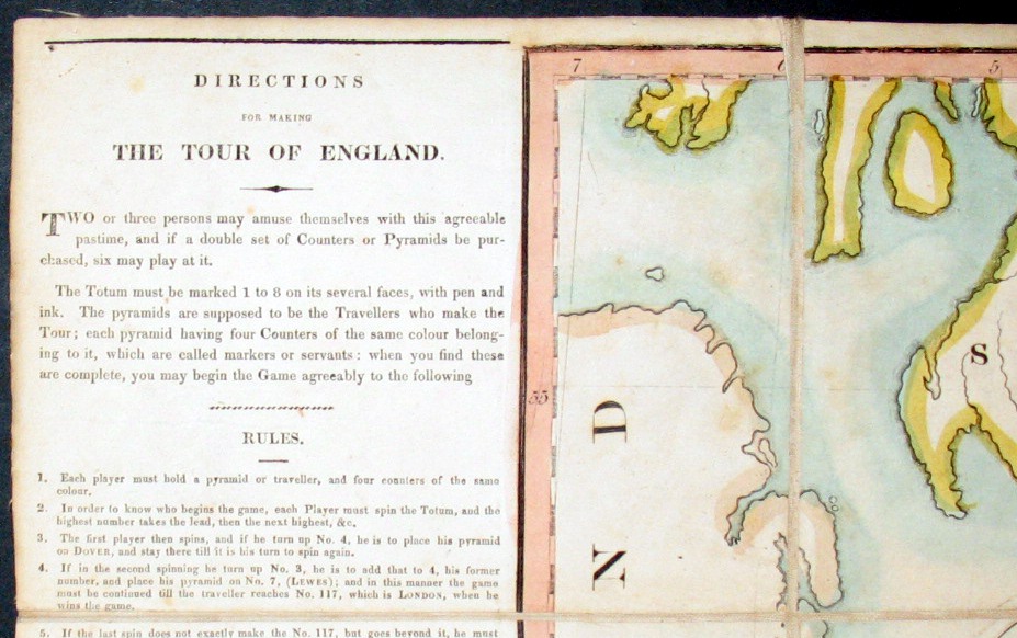
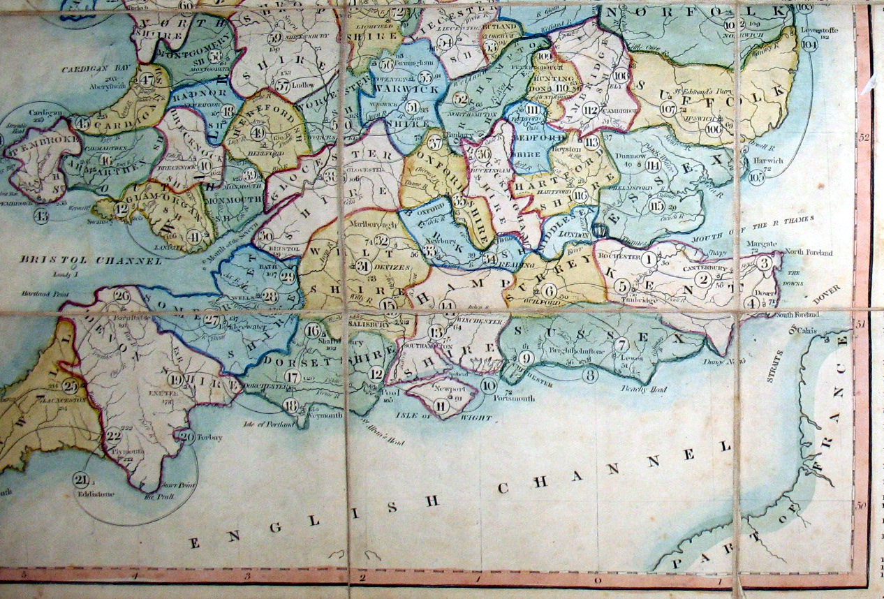
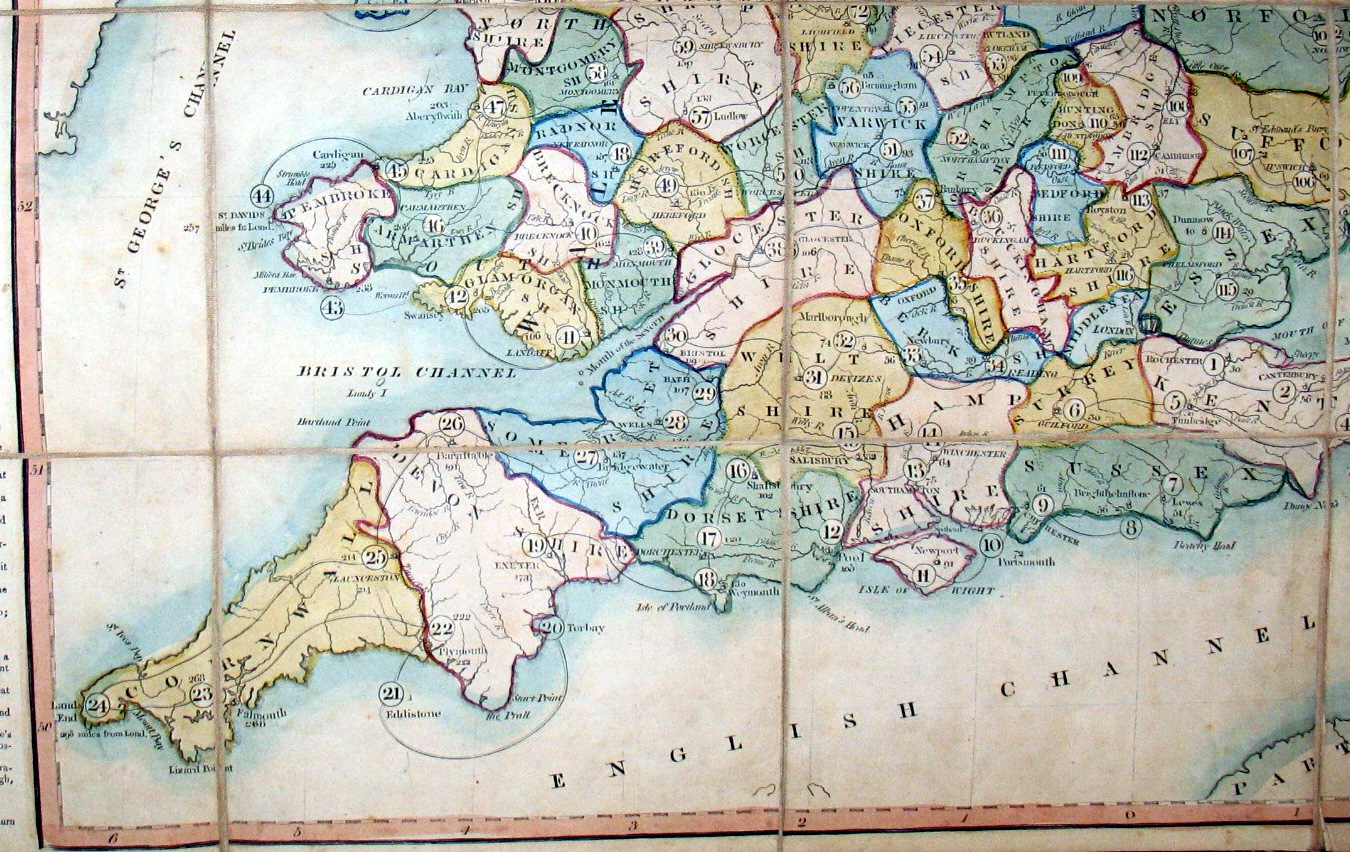
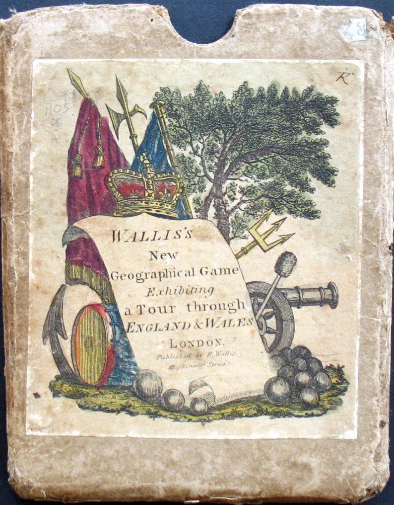
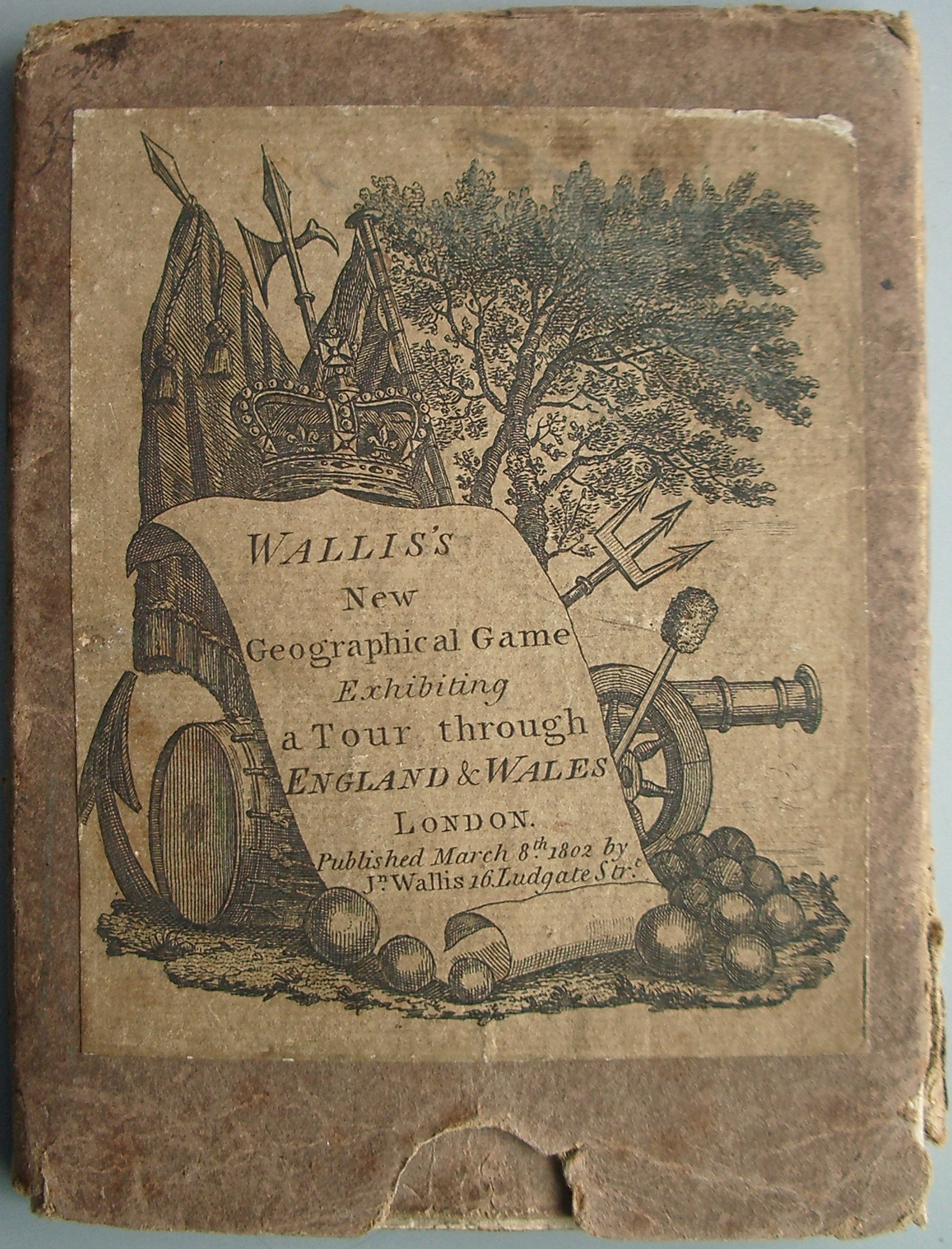
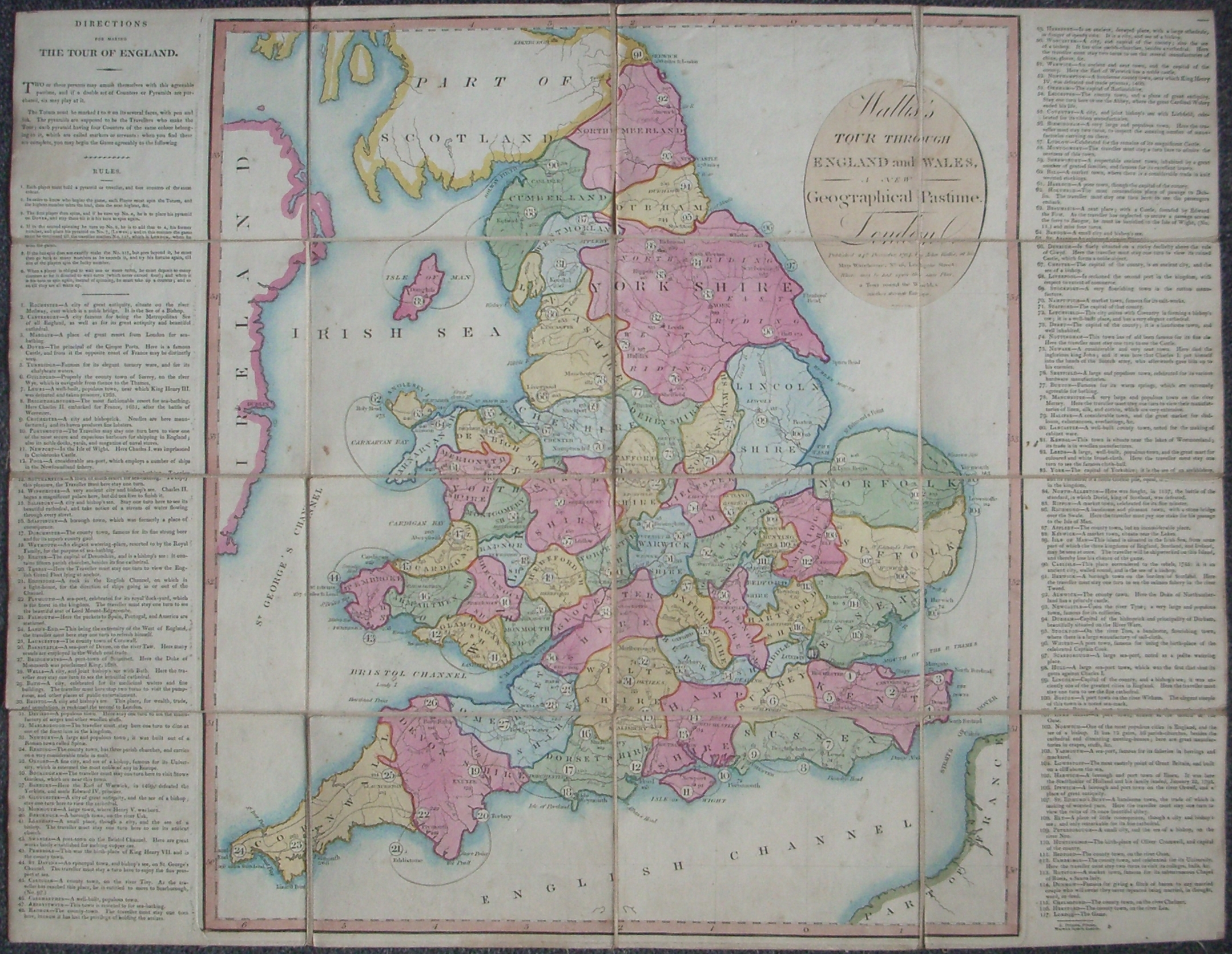
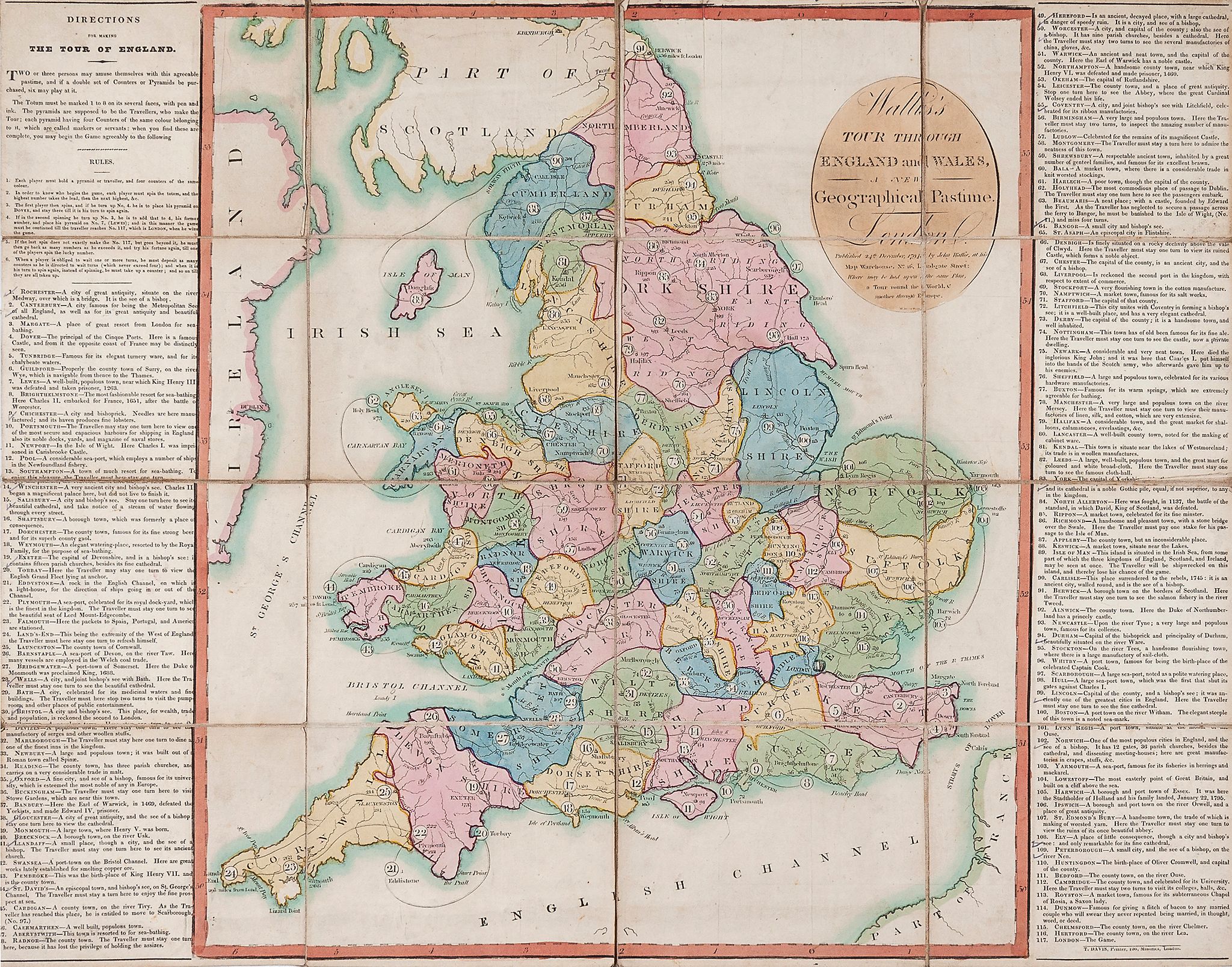
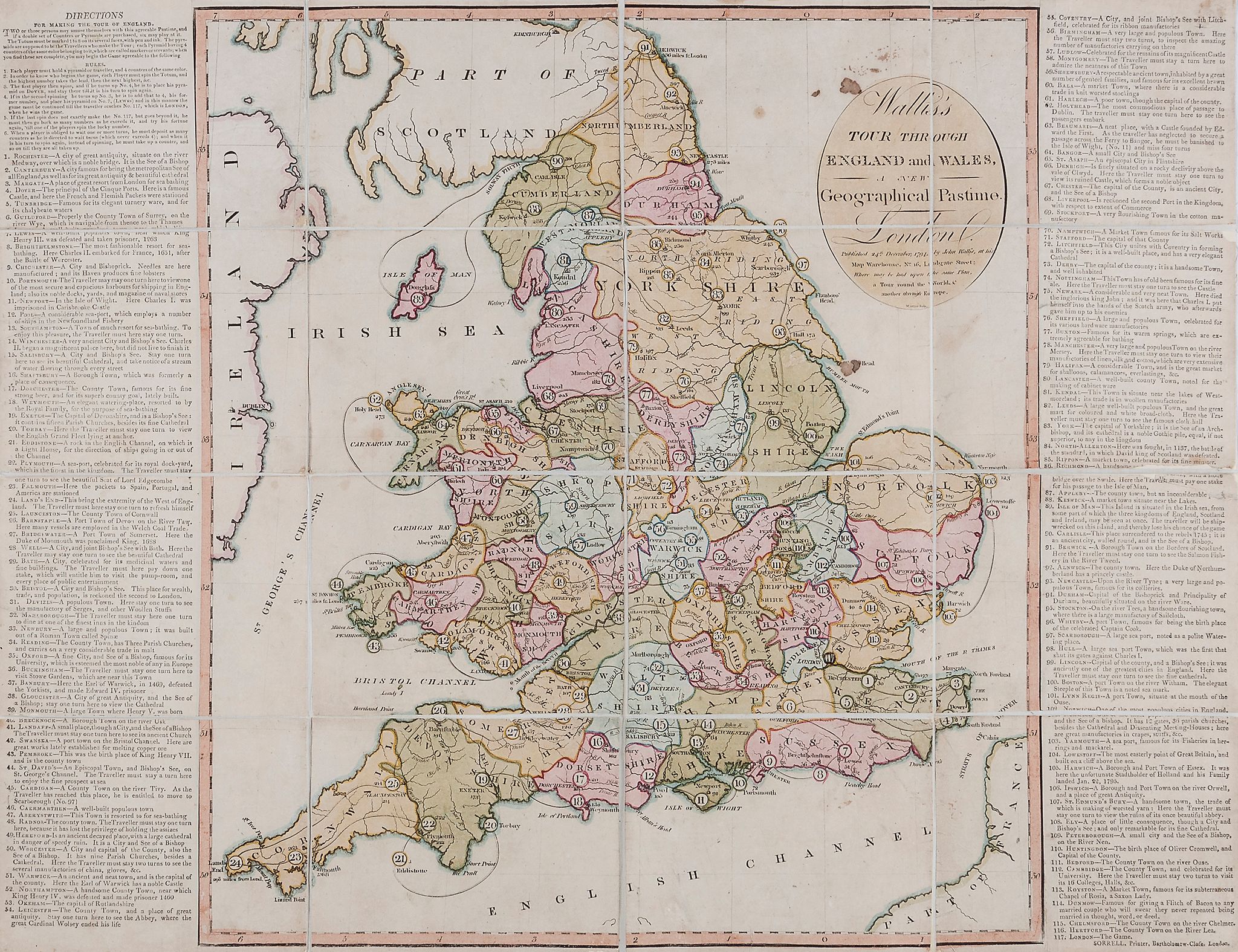
Gioco di 117 (Londra) caselle numerate disposte sulla carta geografica dell'Inghilterra. Alla partenza ogni giocatore ha una pedina, chiamato un viaggiatore e quattro gettoni che conserva. La maggior parte delle penalità implica di saltare un turno e due di queste necessitano anche di un pagamento. E' l'isola di Man che ha la penalità maggiore: in questa casella la nave del viaggiatore fa naufragio e il giocatore deve lasciare la partita. La descrizione delle città mette in risalto le loro caratteristiche commerciali. Molte le città menzionate: Worcester per le sue porcellane e i suoi guanti; Manchester e Leeds per i loro vestiti e Berwick per le sue pescherie di salmone. Le regole di questo gioco furono stampate nel 1802. REGOLE: a destra e sinistra sul tavoliere. CASELLE: mute. REFERENZA 1 "Wallis's Tour through England and Wales. A New Geographical Pastime. V&A Museum In order to play this race game through England and Wales, each player must have a marker, usually in the shape of a pyramid, and four counters. An eight-sided teetotum spinner is also needed. There are 117 playing spaces each designating a place, beginning with Rochester and ending in London. These places and their descriptions are listed at the sides of the playing surface with any rewards or penalties for landing on them. The worst place to land is the Isle of Man, where the traveller is shipwrecked and has to leave the game. The descriptions of the towns, while still creating the illusion of a visit to an interesting place, highlight the idea of commerce and trade. Many manufacturing towns are mentioned, including Worcester for its china and gloves, Manchester and Leeds for their cloths, and Berwick for its salmon fisheries. Physical description Design: engraving, coloured by hand; paper in 16 sections mounted on linen with the principal towns and cities numbered N°of squares: 117 Squares illustrated: all over map Square numbering: 1-117 Squares titled: all Subject of starting square: Rochester Subject of ending square: London Place of Origin: London Date: 24/12/1794 Artist/maker: Wallis, John Materials and Techniques: Hand-coloured engraved paper on linen Dimensions: Length: 52 cm; width: 67.2 cm Object history note The game is lettered McINTYRE SCULPSIT LONDON PUBLISHED 24th December 1794 BY JOHN WALLIS AT HIS MAP WAREHOUSE NO. 16 LUDGATE STREET. Slipcase is lettered PUBLISHED MARCH 8th 1802 BY JN WALLIS AT HIS MAP WAREHOUSE LUDGATE STREET.; on the rules in letterpress PRINTED BY J CROWDE WARWICK SQUARE Historical context note Rewards: collecting tokens (see rules) and forward movement Forfeits: missing turns and backward movement N°of Players: 2 to 6 Equipment required: teetotum; markers and counters - see rules for description Rules: DIRECTIONS FOR MAKING THE TOUR OF EUROPE Two or three persons may amuse themselves with this agreeable pastime, and if a double set of Counters and Pyramids are purchased, six may play at it. The Totum must be figures 1 to 8 on its several faces, in pen and ink. The pyramids are supposed to be the travellers who make the tour; each pyramid having 4 counters of the same colour belong to it, which are called markers or servants: when you find that these are complete, you may begin the game agreeable to the following rules. 1. Each player must hold a pyramid or traveller, and four counters of the same colour. 2. In order to know who begins the game, each player must spin the Totum, and the highest number takes the lead, then the next highest, etc. 3. The first player then spins, and if he turns up No. 4, he is to place his pyramid on Hanover, and stay there till it is his turn to spin again. 4. If in the second spinning he turns up No. 3, he is to add that to 4, his former number, and place his pyramid on No. 7 (Carlesroma) and in this manner the game must be continued till the traveller reaches No. 102, which is London, the first city in Europe; when he wins the game. 5. If the last spin does not exactly make up to the No.102, but goes beyond it, he must then go back as many numbers as he exceeds it, an try his fortune again, till one of the players spins the lucky number. 6. When a player is obliged to wait one or more turns, he must deposit as many counters as he is directed to wait turns (which never exceed four) and when it is his turn to spin again, instead of spinning, he must take up a counter, and so on till they are all taken up. EACH OF THE TOWNS LISTED HAS A SHORT DESCRIPTION The engraved label on the slip case shows military trophies, with a royal crown and a scroll of paper with the title. *Like A NEW ROYAL GEOGRAPHICAL PASTIME (E.5307-1960), the towns and descriptions are shown together with any rewards or penalties, in this case there are only 117 compartments. Although the basic playing method is the same, there is one major difference and that is the kitty. To start, each player has a marker, called a traveller, and four counters, which are kept. Most of the forfeits involve missing turns, but two ask for payment. The Isle of Man is the harshest,. There the traveller is shipwrecked and has to leave the game. The descriptions of the towns, while still creating the illusion of a visit to an interesting place, high light the idea of commerce and trade. Many manufacturing towns are mentioned, including Worcester for its china and gloves, Manchester and Leeds for their cloths, and Berwick for its salmon fisheries. This game continued for many years and the rules booklet for this example was printed in 1802. Rules placement: printed separately and placed either side of the playing sheet Descriptive line: Hand coloured geographical game, Tour Through England and Wales, published in England by John Wallis in 1794. REFERENZA 2 WHITEHOUSE, Francis Reginald Beaman, (pag. 9): WALLIS'S TOUR THROUGH ENGLAND AND WALES a new Geographical Pastime. London. Published 24 December I794 by John Wallis at his Map Warehouse No 16 Ludgate Street: where may be had upon the same plan A TOUR ROUND THE WORLD and another THROUGH EUROPE. This is a companion game to the last one described, published one month later: another edition was published 8th March, 1802 at 16 Ludgate Street. The chief interest in this game lies in the descriptions of the towns. Starting at No 1 Rochester and finishing at 117 London it visits, e.g. : 8 BRIGHTHELMSTONE (Brighton). Here Charles II embarked for France 1651 after the Battle of Worcester. 27 BRIDGEWATER. A port town of Somerset. Here the Duke of Monmouth was proclaimed King 1688. (Just over 100 years ago.) 32 MARLBOROUGH. The traveller must stay here one turn, to dine at one of the finest Inns in the Kingdom. 49 HEREFORD. An ancient decayed place with a large Cathedral in danger of speedy ruin. 59 SHREWSBURY. A respectable ancient town, inhabited by a great number of genteel families, and famous for its excellent brawn. 79 HALIFAX. A considerable town and is the great market for SHALLOONS, CALLIMANCOES, EVERLASTINGS, etc. 90 CARLISLE. This place surrendered to the Rebels 1745 (49 years ago). 102 NORWICH. One of the most populous cities in England. It has 12 gates, 36 Parish Churches besides the Cathedral and Dissenting Meeting Houses. REFERENZA 3 "Wallis's Tour through England and Wales. A new Geographical Pastime (A travers l'Angleterre et le pays de Galles, un nouveau jeu géographique de Wallis) fut édité par John Wallis le 24 décembre 1794; il s'agit d'une gravure colorée à la main en 16 sections montées sur lin. Comme dans "La nouvelle géographie anglaise et galloise", les villes et les descriptions sont mises en parallèle avec des récompenses et des pénalités, mais le jeu ne présente que 117 compartiments. Bien que le principe du jeu soit le meme, il y a une différence majeure: la cagnotte. Au départ, chaque joueur a un pion, appelé un voyageur et quatre jetons qu'il conserve. La plupart des pénalités impliquent de passer son tour, mais deux d'entre elles nécessitent un paiement. C'est l'ile de Man qui a la pénalité la plus lourde. A cet endroit, le bateau du voyageur fait naufrage et le joueur doit abandonner la partie. Les description des villes mettent surtout en exergue le notions de commerce et d'échange. De nombreuses villes industrielles sont mentionnées, y compris Worcester pour sa porcelaine et ses gants. Manchester et Leeds pour leurs vetement et Berwick pour ses pecheries de saumon. Ce jeu fut disponible de nombreuses années; les règles de cet exemplaire furent imprimées en 1802. (GOODFELLOW Caroline) REFERENZA 4 "Wallis's Tour through England and Wales. A new Geographical Pastime was published by John Wallis on December 24th, 1794 and was a hand-coloured engraving in 16 sections mounted on linen. Like "A New Royal Geographil Pastime for England and Wales", the towns and descriptions are shown together with any rewards or penalties, but in this case there are only 117 compartments. Although the basic playing method is the same, there is one major difference and that is the kitty. To start, each player has a marker, called a traveller, and four counters, which are kept. Most of the forfeits involve missing turns, but two ask for payment. The Isle of Man is the harshest.There the traveller is shipwrecked and has to leave the game. The descriptions of the towns, while still creating the illusion of a visit to an interesting place, highlight the idea of commerce and trade. Many manufacturing towns are mentioned, including Worcester for its china and gloves, Manchester and Leeds for their cloth, and Berwick for its salmon fisheries. This game continued to be available for many years, and the rules booklet for this example was printed in 1802." (GOODFELLOW Caroline) Exhibitions: - "Instruction and Delight: Children's Games from the Ellen and Arthur Liman Collection" (Yale Center for British Art, 17 January-23 May, 2019). |
|
| bibliografia: |
1) WHITEHAUSE, F.R.B.: "Table Games of Georgian and Victorian Days", London, Peter Garnett, 1951. 2) GOODFELLOW, Caroline: "A Collector's Guide to Games and Puzzles". Secaucus, New Jersey, Chartwell Books-London, Quintet Publishing Limited 1991. 3) GOODFELLOW, Caroline: "The Development of the English Board Game, 1770-1850", in Board Games Studies 1, 1998. 4) GOODFELLOW, Caroline: "Jeux de société. Le guide du collectionneur des jeux de société depuis le XVIIIe siècle jusquà nos jours", (Edizione francese) Carrousel MS, 2001. 5) SEVILLE, Adrian: "The Game of Goose: and its influence on cartographical race games" Journal of the International Map Collectors' Society, Winter 2008 N°115 2008. 6) SEVILLE, Adrian: "The geographical Jeux de l'Oie of Europe." In "Belgeo" 2008 3-4 2008. 7) GOODFELLOW, Caroline: "How We Played: Games From Childhood Past", History Press, 2012. 8) QUINN, Brian - CARTWRIGHT, William: "Geographic Board Games". Geospatial Science Research 3. School of Mathematical and Geospatial Science, RMIT University, Australia. December 2014. 9) SEVILLE, Adrian: "The Royal Game of the Goose four hundred years of printed Board Games". Catalogue of an Exhibition at the Grolier Club, February 23 - May 14, 2016. 10) LIMAN, Ellen: "Georgian and Victorian Board Games: The Liman Collection", Pointed Leaf Press, 2017. 11) NORCIA, Megan A.: "Gaming Empire in Children's British Board Games, 1836-1860". Studies in Childhood, 1700 to the Present. Routledge, 2019. 12) SEVILLE, Adrian: "L'arte dei giochi da tavolo. Oltre un secolo di storia e divertimento dalla fine del Settecento all'inizio del Novecento." Edizioni White Star, 2019. 13) PARLAK, Omer Fatih: "Seafearing through the Perspective of Historic Board Games", in DGSM, Köllen Druck+Verlag, Bonn 2020. |
|
| "The Development of the English Board Game, 1770-1850" (Caroline G. Goodfellow) | ||
| Geographical Games. "Table Games of Georgian and Victorian Days". (Francis Reginald Beaman, Whitehause) | ||
Vai alla ricerca giochi Vai all'elenco autori