Giochi dell'Oca e di percorso
(by Luigi Ciompi & Adrian Seville)
(by Luigi Ciompi & Adrian Seville)
|
Giochi dell'Oca e di percorso
(by Luigi Ciompi & Adrian Seville) |
|
|
 |
Torna alla ricerca giochi (back to game search) |
 |
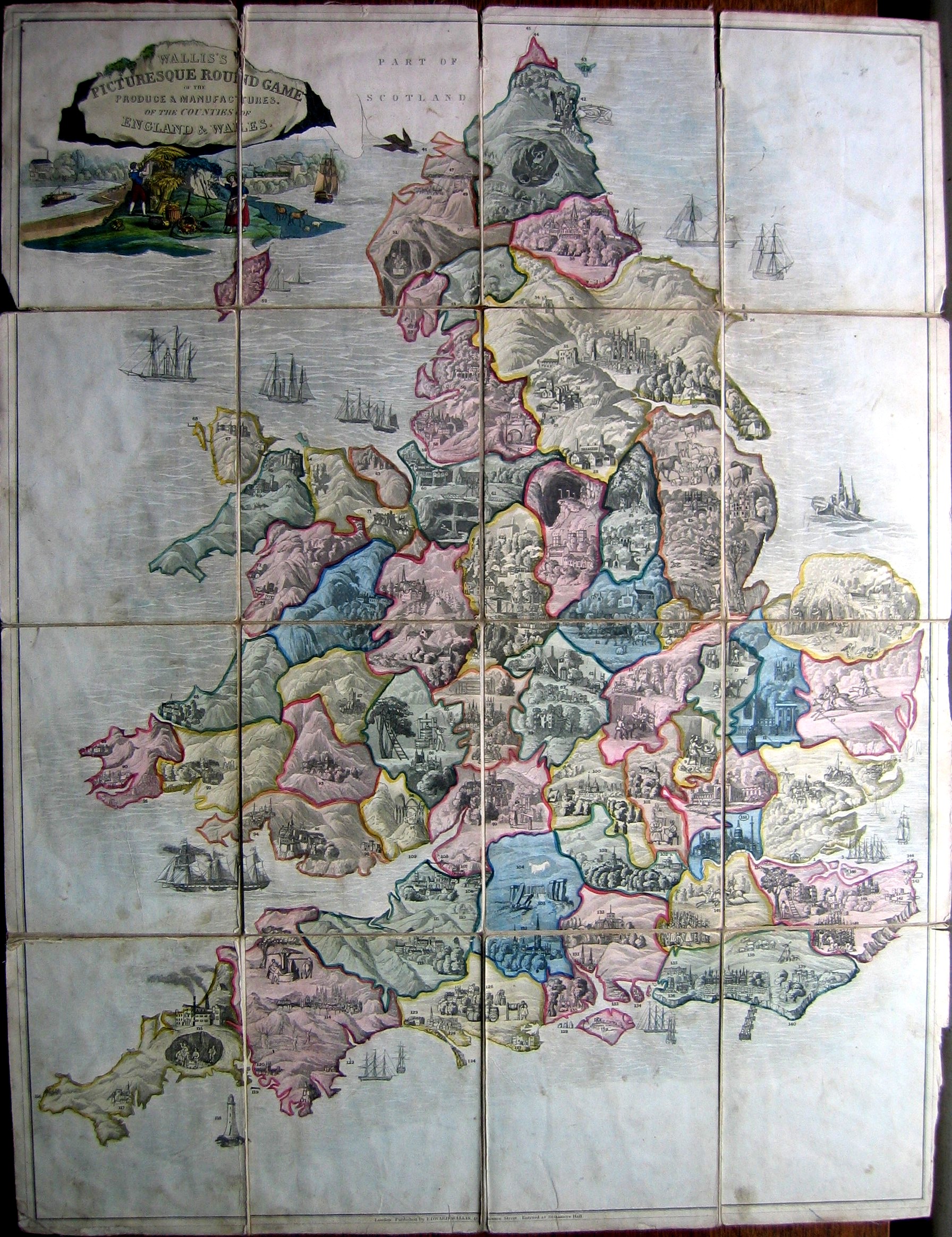
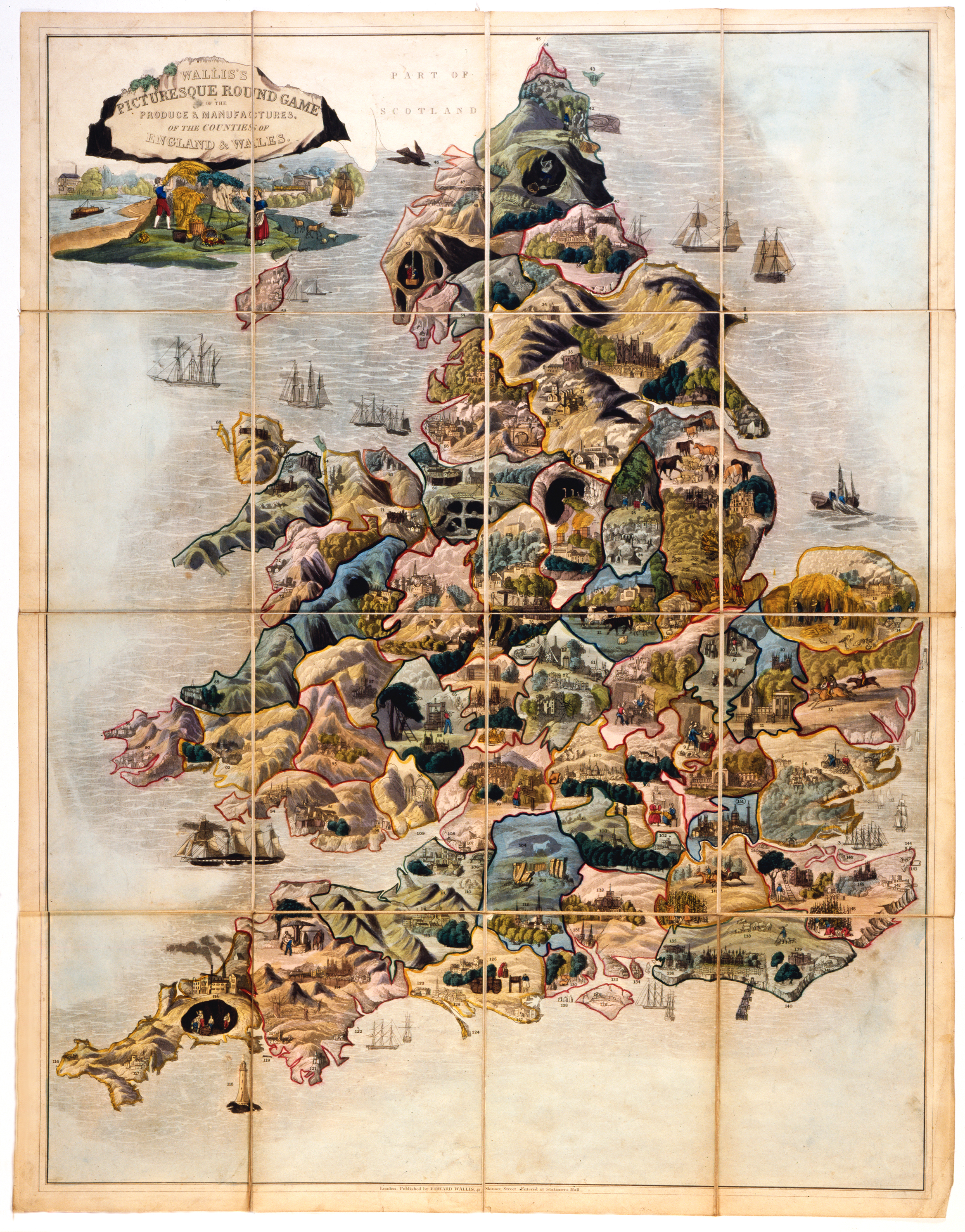
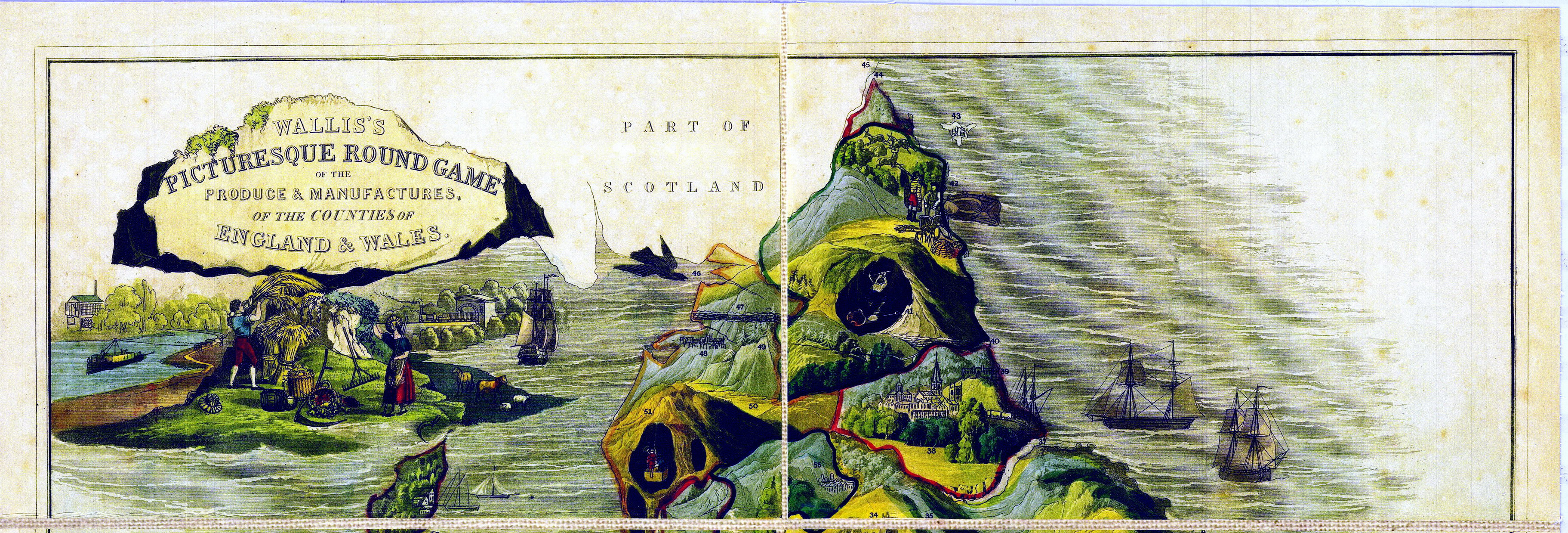
| Wallis's Picturesque Round Game of the Produce & Manufactures of the Counties of England & Wales | ||
 |
Versione stampabile
 |
Invia una segnalazione

|
                   |
primo autore: | Non indicato |
| secondo autore: | Wallis | |
| anno: | 1826/37 | |
| luogo: |
Inghilterra-Londra |
|
| periodo: | XIX secolo (2° /4) | |
| percorso: | Percorso di 151 caselle numerate | |
| materiale: | carta incollata su tela (engraving on paper with linen backing) | |
| dimensioni: | 660X512 (673X552) | |
| stampa: | Litografia (gravure) (engraving) | |
| luogo acquisto: | Inghilterra-Londra | |
| data acquisto: | ||
| dimensioni confezione: | ||
| numero caselle: | 151 | |
| categoria: | Agricoltura, Industria, Commercio, Esposizioni, Arti e Mestieri | |
| tipo di gioco: | Gioco di percorso | |
| editore: | Published by Edward Wallis, 42, Skinner Street. | |
| stampatore: | Published by Edward Wallis, 42, Skinner Street. | |
| proprietario: | Collezione A. Seville - E. C. - L. Ciompi | |
| autore delle foto: | A. Seville - E. C. - L. Ciompi | |
| numero di catalogo: | 979 | |
| descrizione: |
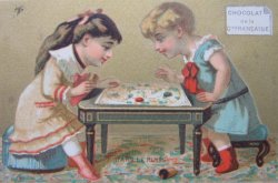
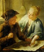
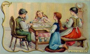
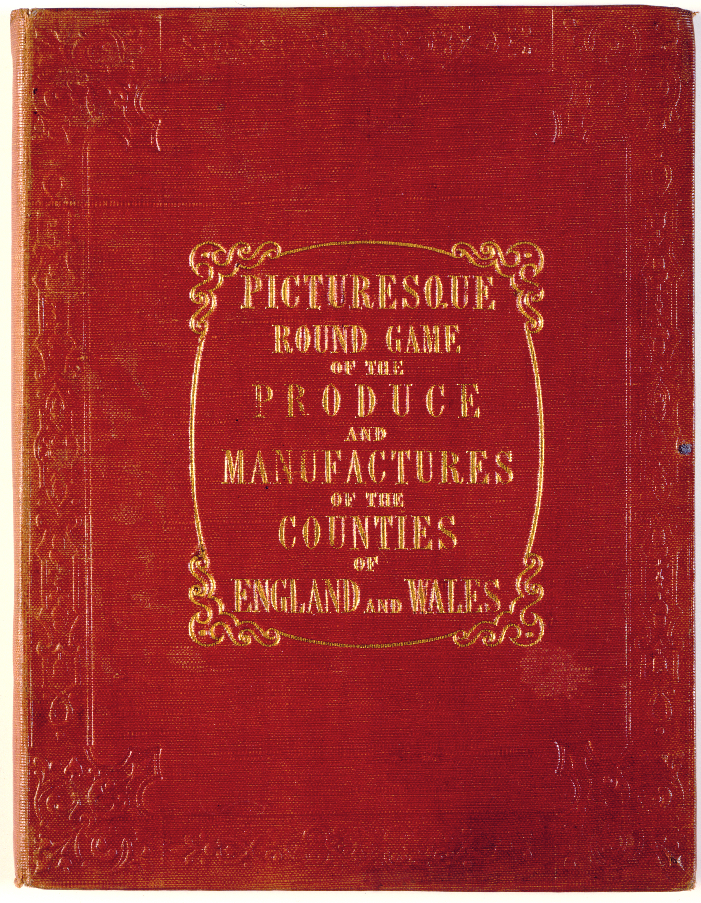
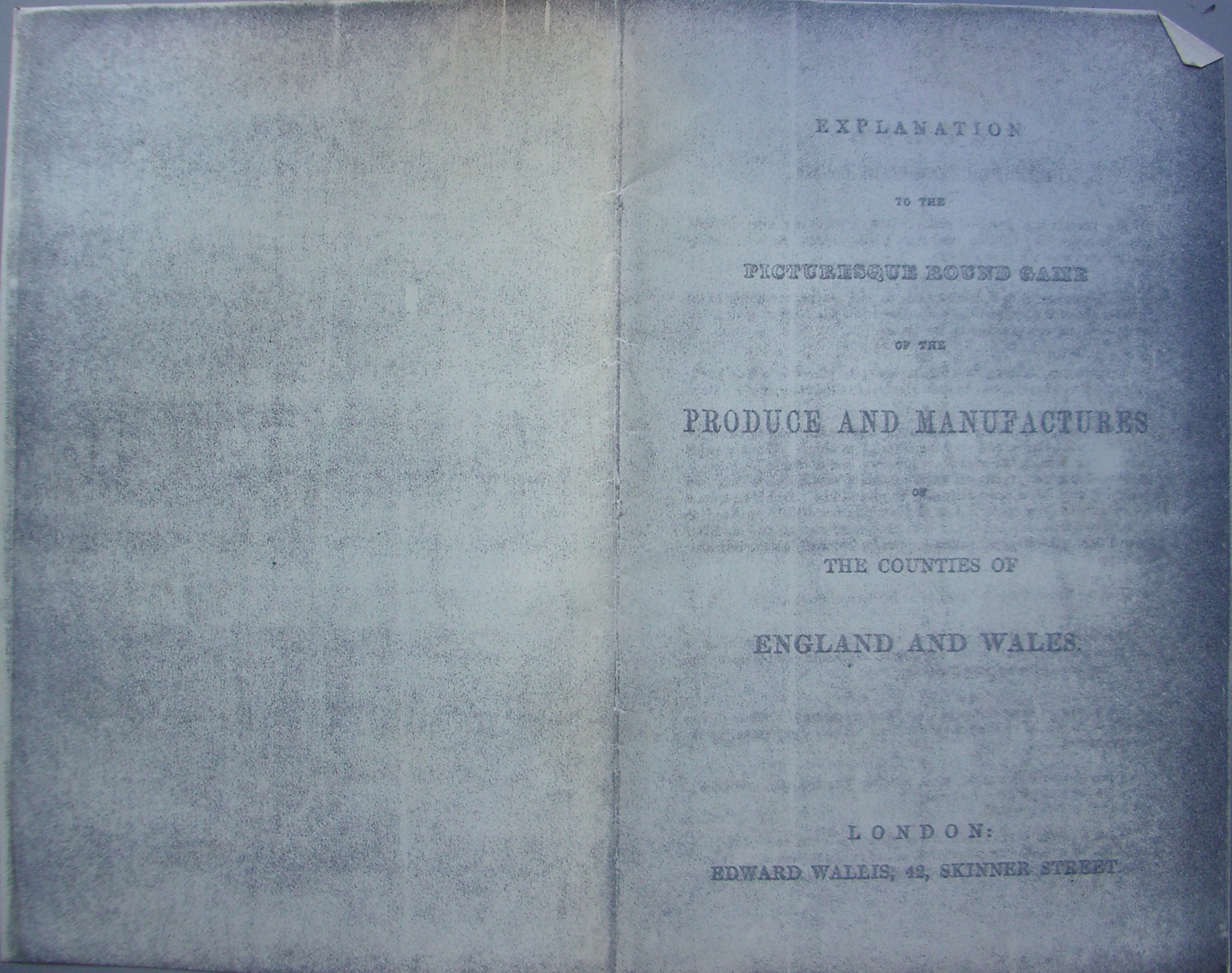
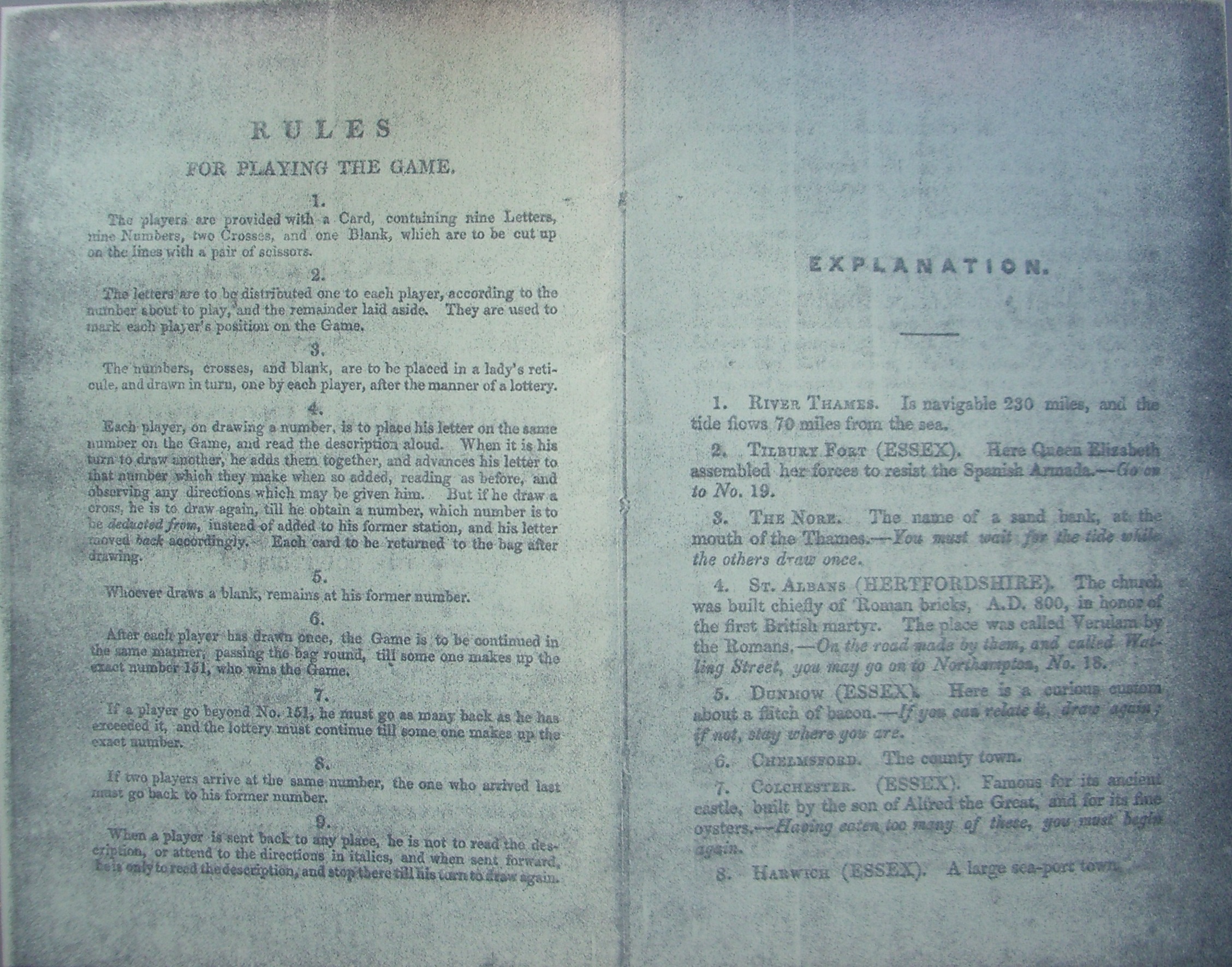
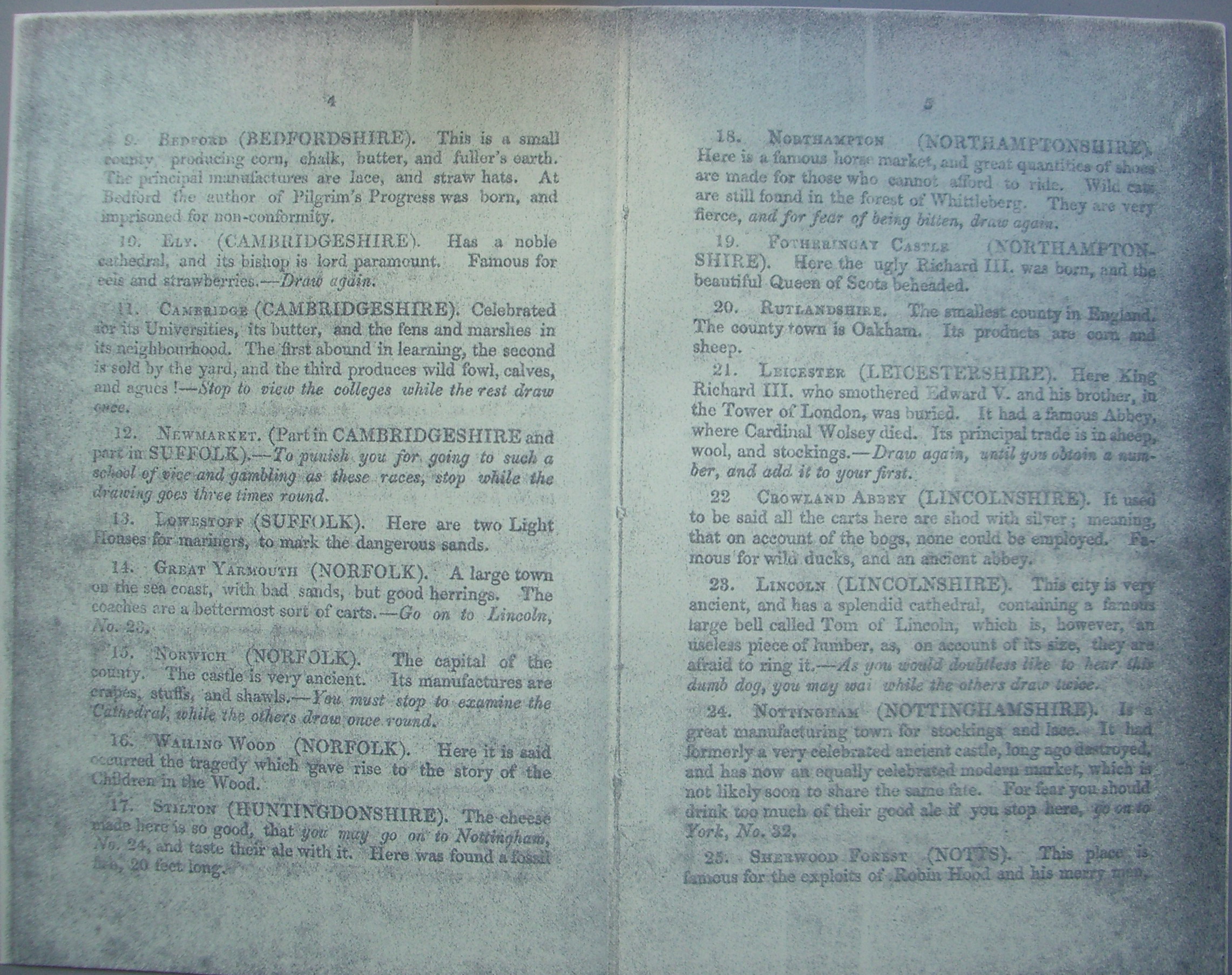
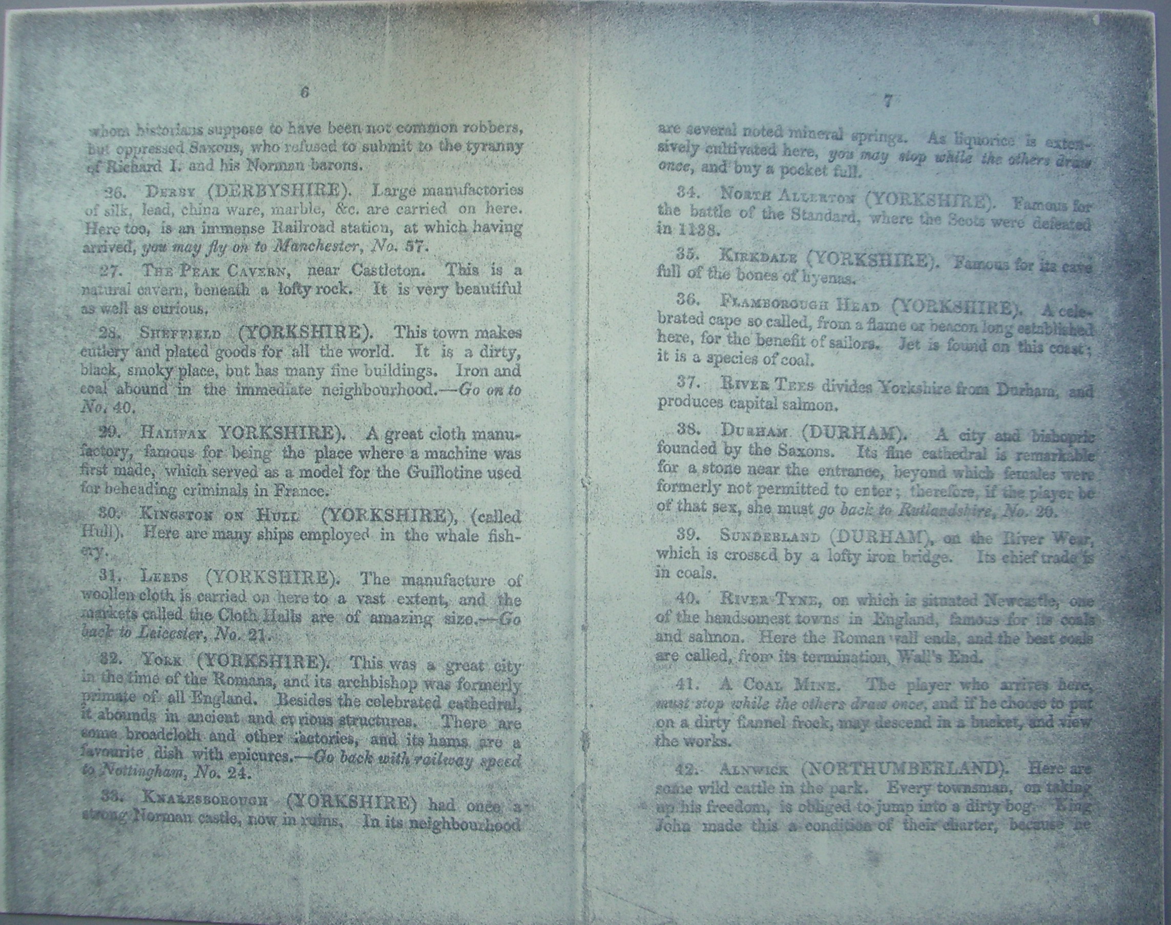
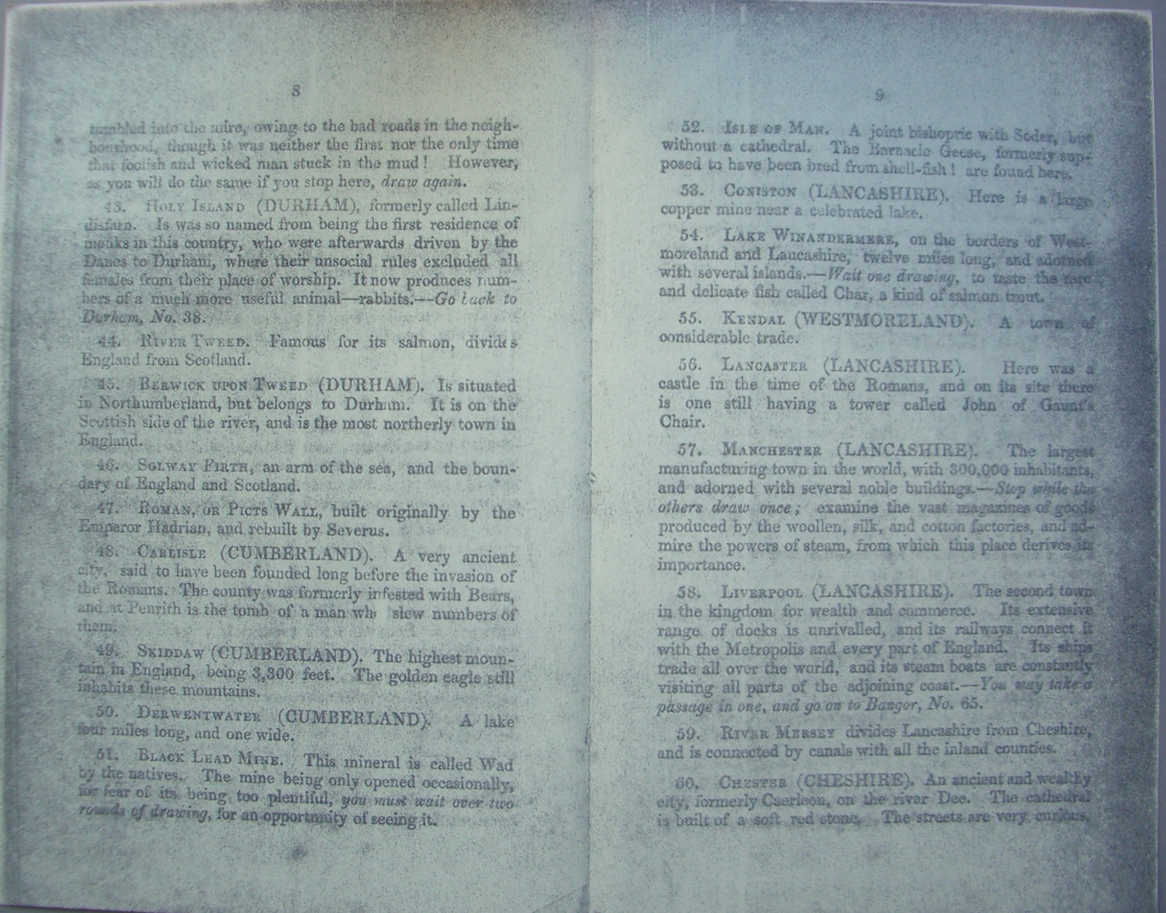
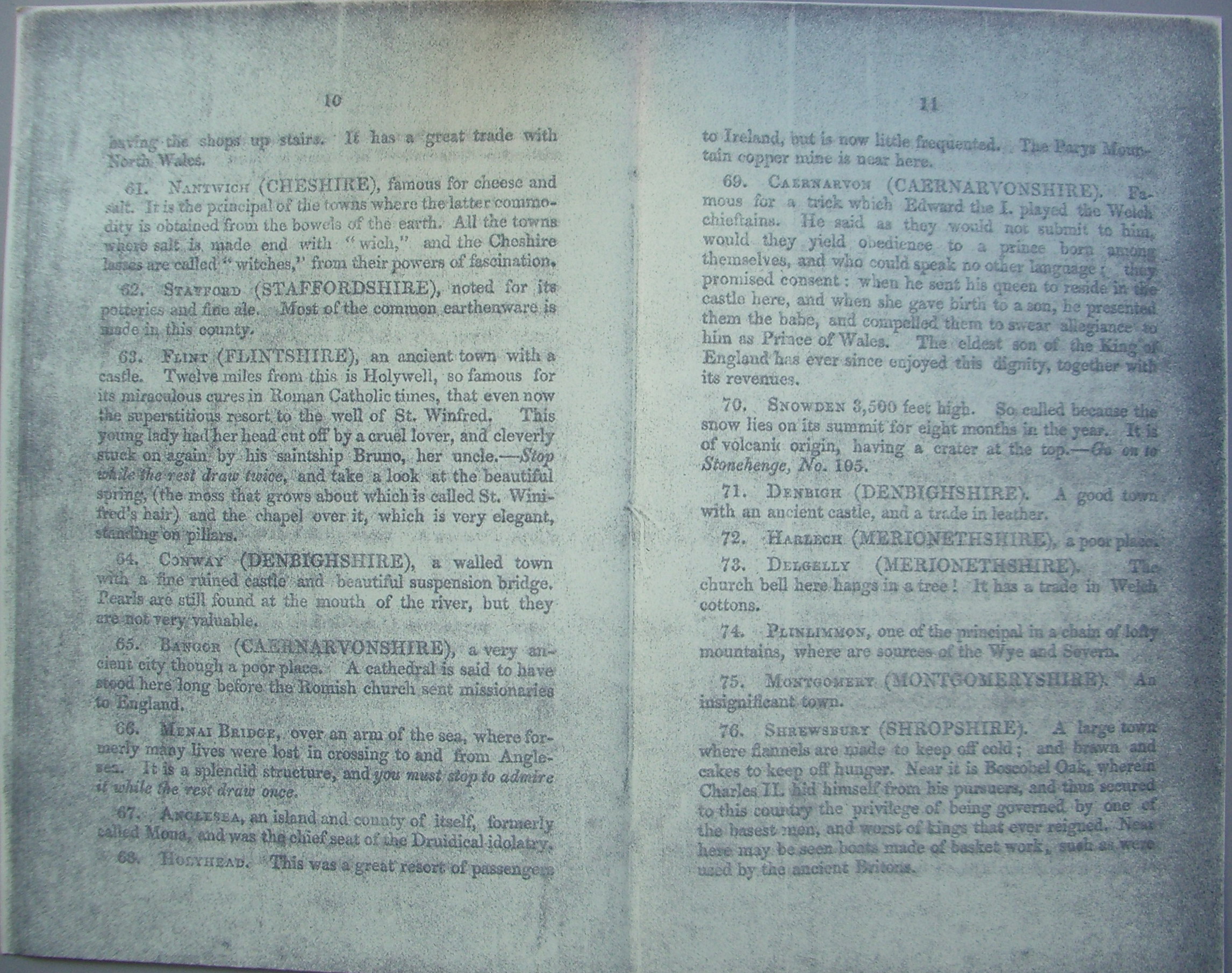
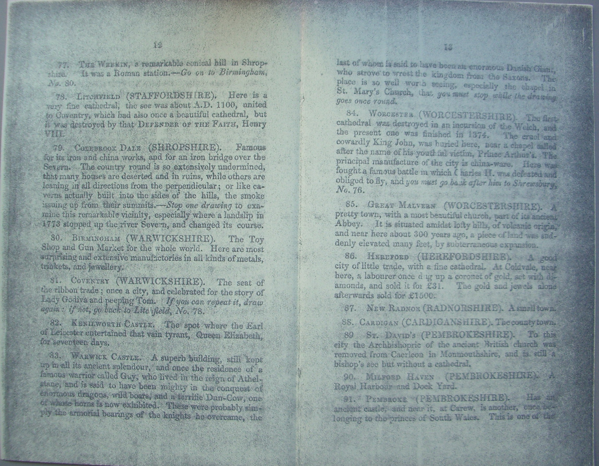
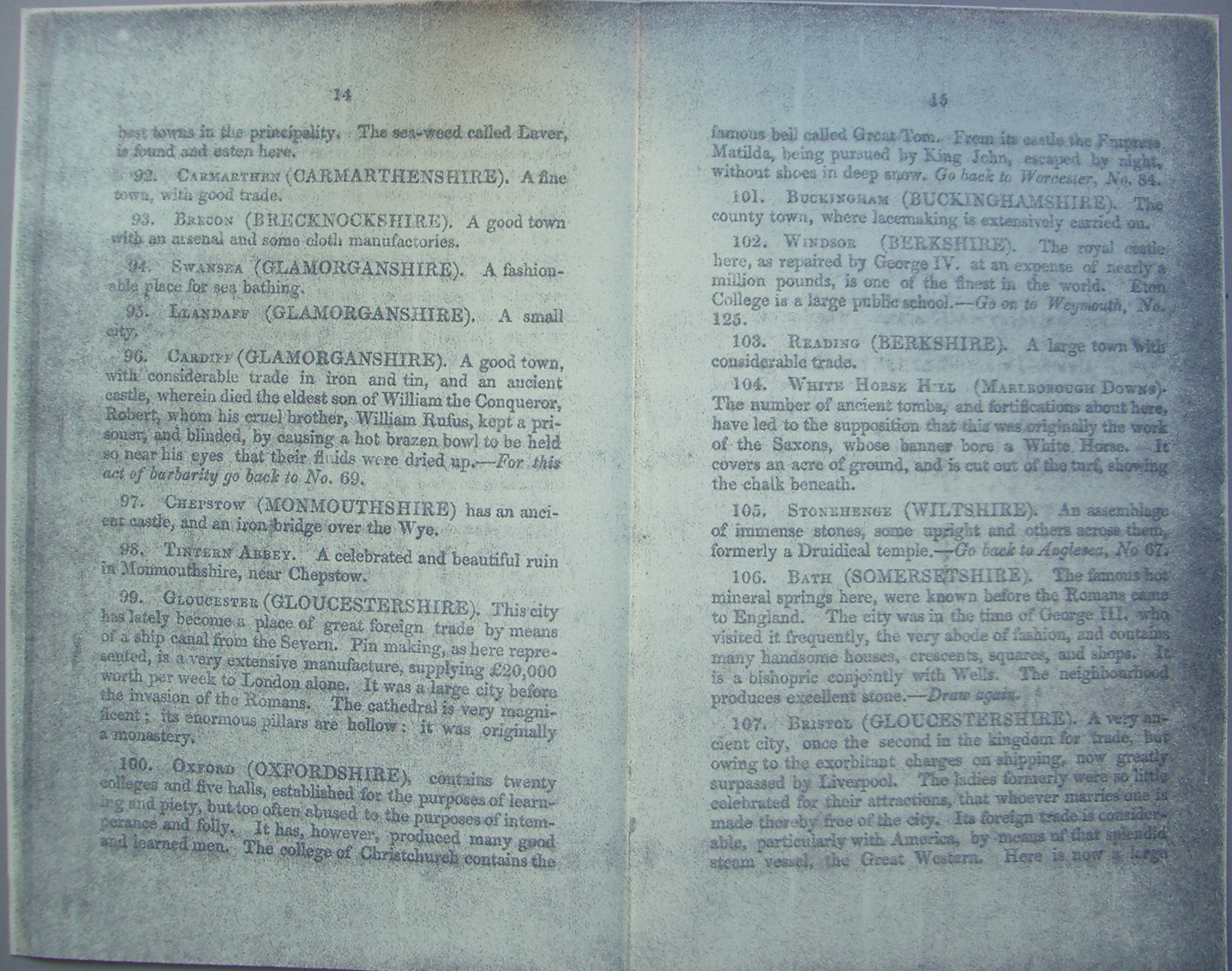
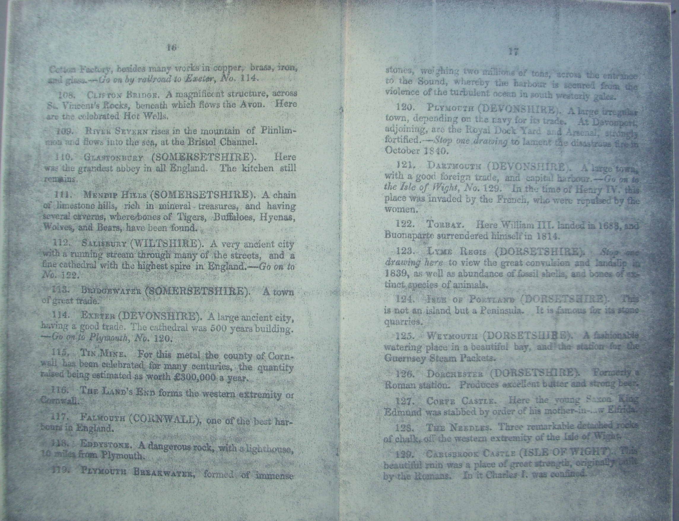
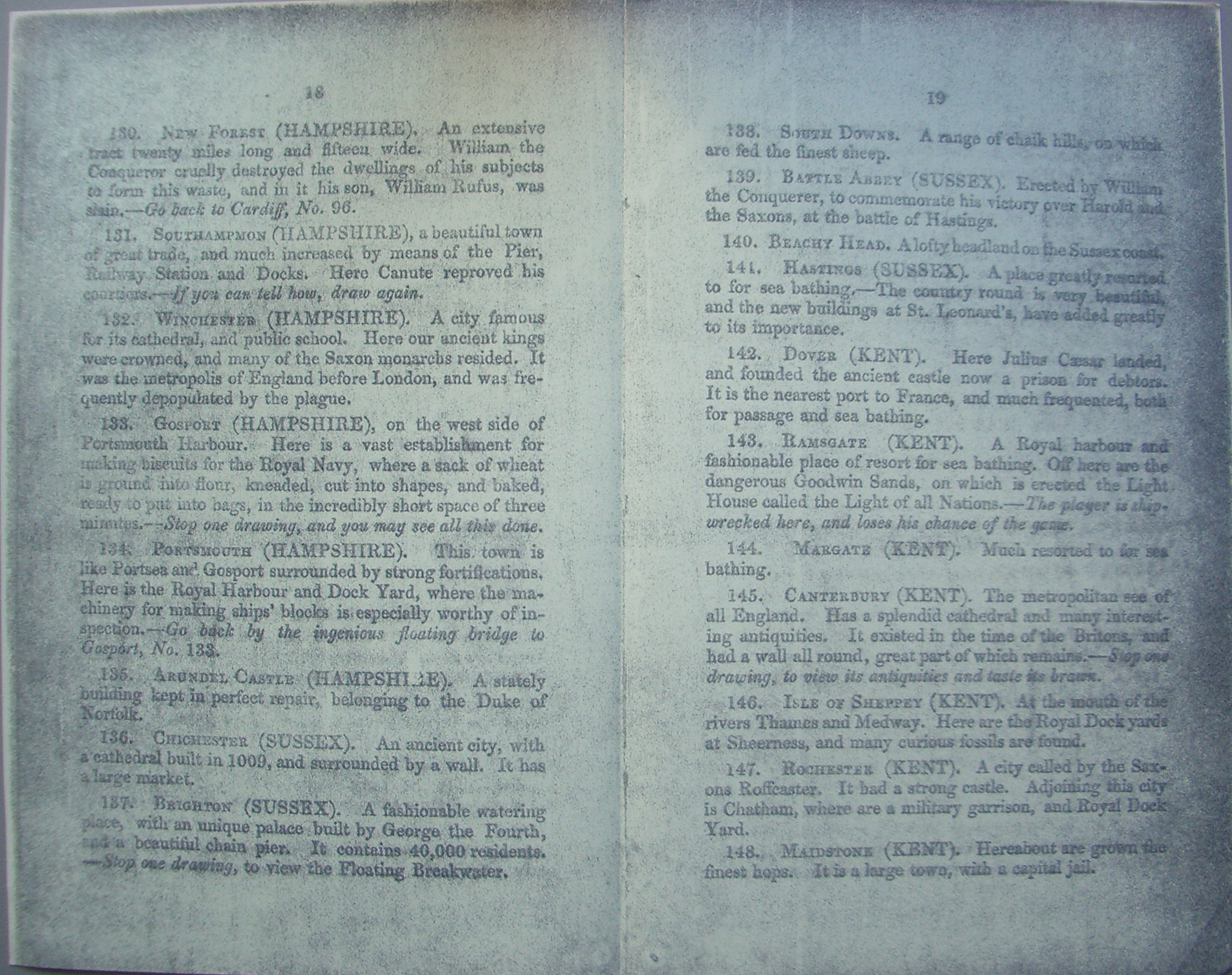
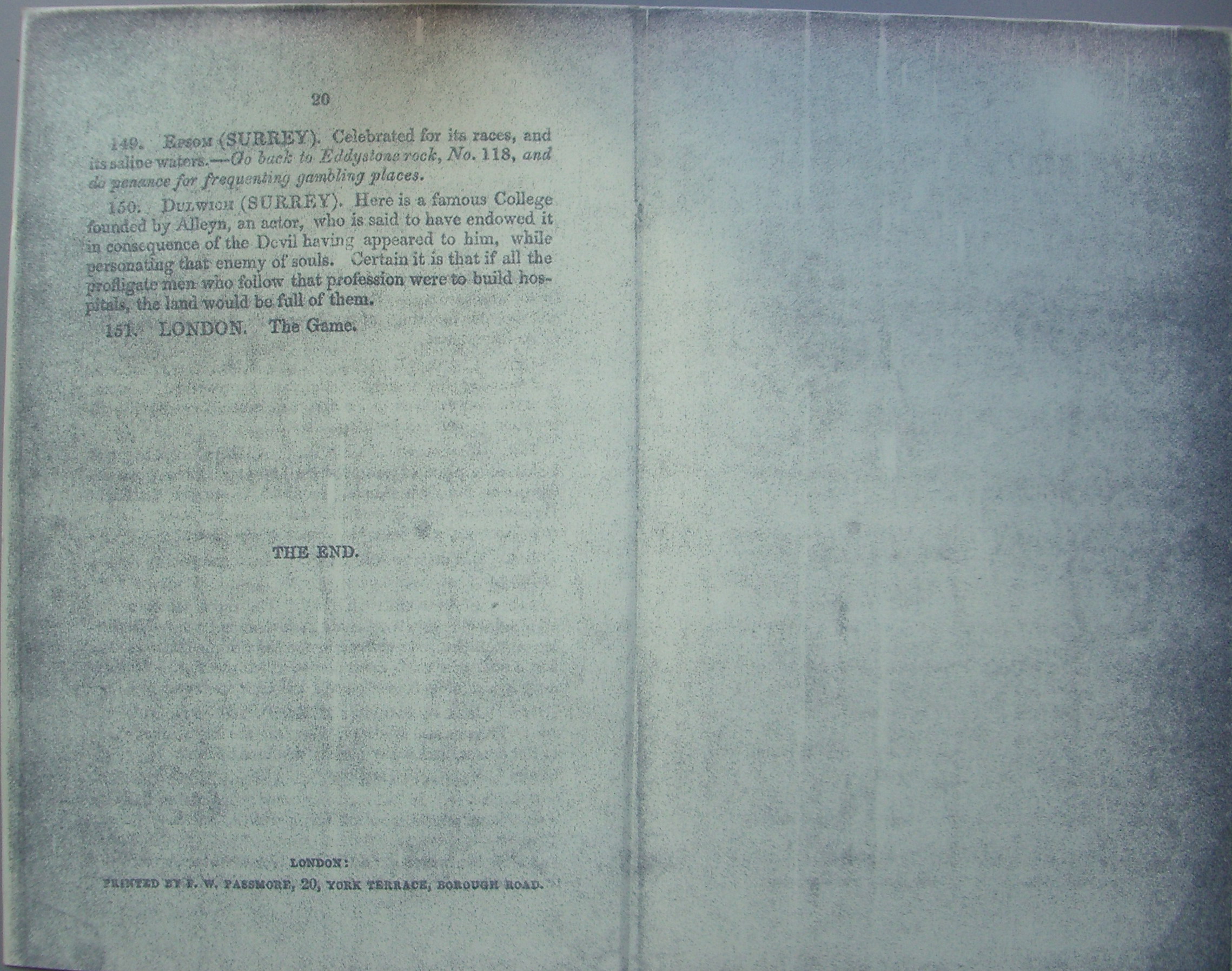
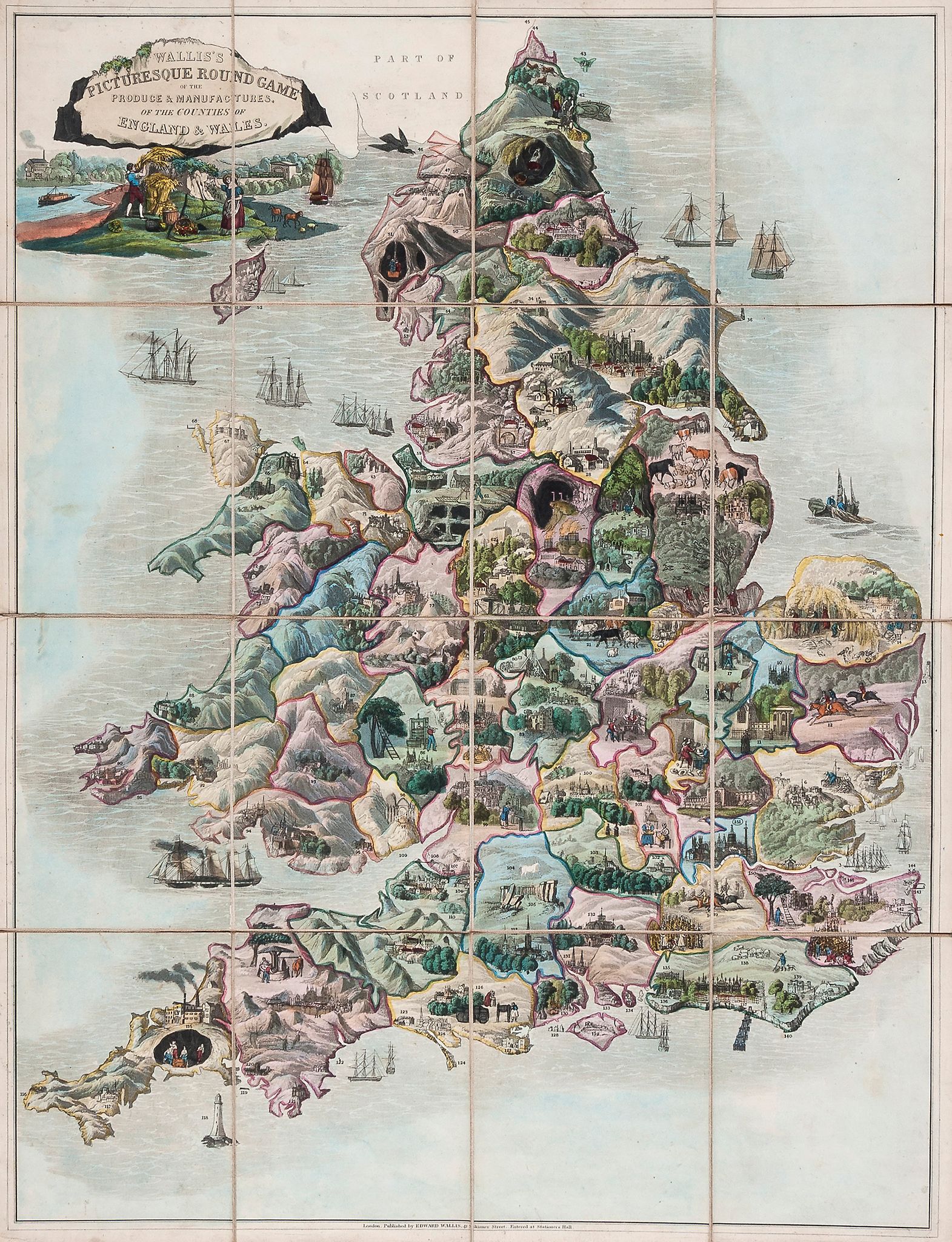
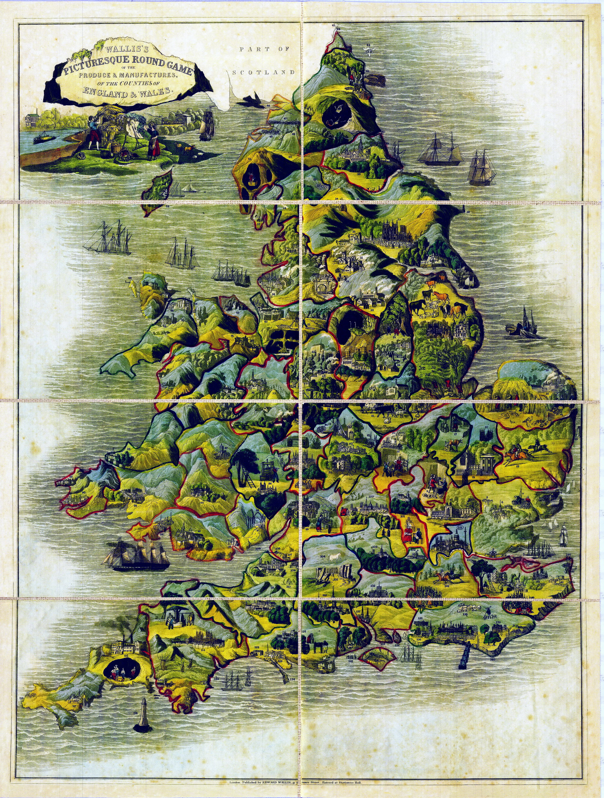
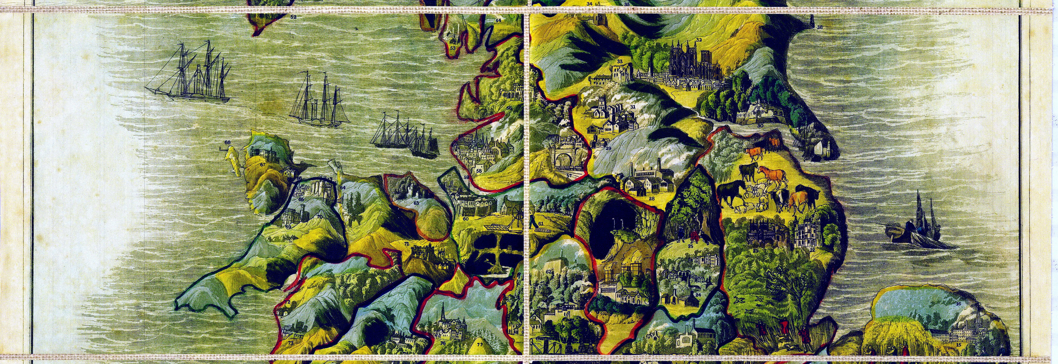
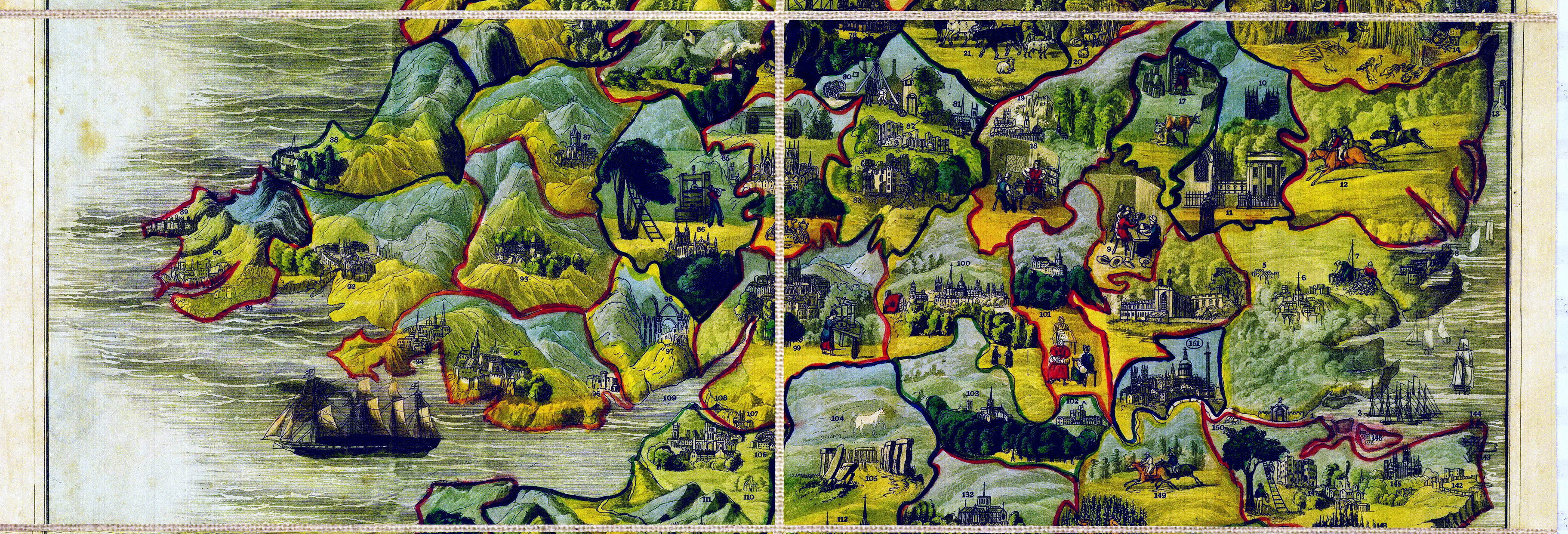
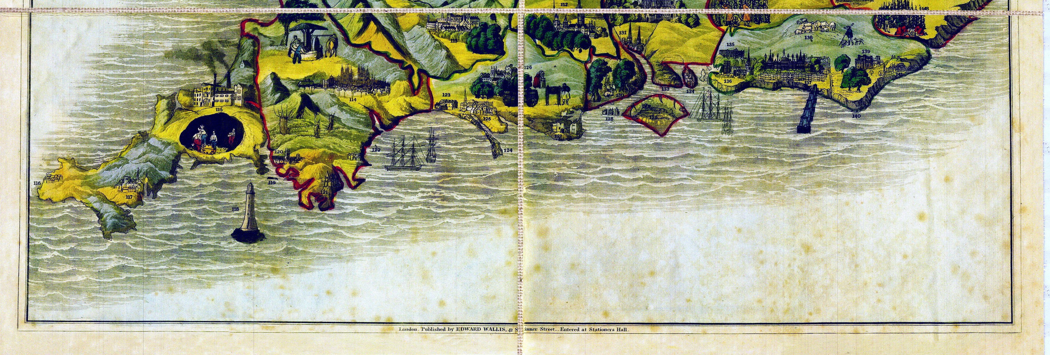
Gioco di 151 caselle numerate distribuite sulla carta geografica dell'Inghilterra. REGOLE: non riportate sul tavoliere. CASELLE: mute. REFERENZA 1 "Wallis's Picturesque Round Game of the Produce & Manufactures of the Counties of England & Wales".V&A Museum. This is a geographical race game played on a map of England and Wales. The map is divided into counties with representations of local landmarks and industry. There are 151 playing spaces. The play is a circular one, with the starting space at the River Thames and the end space in London. This particular game was sold by E. Gibbons, dealer in German and French fancy goods, at 15 North Street, Bristol. Physical description Design: etching and aqua tint, coloured by hand; 16 sections mounted on linen showing a map of England and Wales divided into counties with representations of industries etc. N°of squares: 151 Squares illustrated: as a map Square numbering: all Squares titled: in booklet Subject of starting square: River Thames Subject of ending square: London Place of Origin: London Date: ca. 1850 Artist/maker: John Passmore Materials and Techniques: Hand-coloured etching and aquatint on linen Dimensions: Height: 66 cm; width: 51.2 cm Object history note: contained in a cloth covered slip case with stamped gilt title Rule 8 is different as most expect players to exchange places. The game is later than dated as the rules mention October 1840 for the Fire of Plymouth. At address about 1840 to 1869, took over Wallis's stock in 1847. On cover, the label is printed E GIBBONS (LATE MILL) DEALER IN GERMAN AND FRENCH FANCY GOODS, 15 NORTH STREET, BRISTOL. Historical context note Rewards: extra turns and forward movement Forfeits: missing turns, remaining in same place or backward movement N°of Players: any Equipment required: stock of cards pieces provided with the game, as defined in the Rules Rules: RULES FOR PLAYING THE GAME The players are provided with a Card, containing nine Letters, nine Numbers, two Crosses and one Blank, which are to be cut up on the lines with a pair of scissors. 2. The letters are to be distributed one to each player, according to the number about to play, and the remainder laid aside. They are used to mark each player's position o the Game. 3. The numbers, crosses and blank are to be placed in a lady's reticule, and drawn in turn, one by each player, after the manner of a lottery. 4. Each player, on drawing a number, is to place his letter on the same number in the Game, and read the description aloud. When it is his turn to draw another, he adds them together and advances his letter to that number which they make when so added, reading as before, and observing any directions which may be given him. But if he draw a cross, he is to draw again, till he obtain a number, which number is to be deducted from, instead of added to his former station, and his letter moved back accordingly. Each card to be returned to the bag after drawing. 5. Whoever draws a blank, remains at his former number. 6. After each player has drawn once, the Game is to be continued in the same manner, passing the bag round, till some one makes up the exact number 151, who wins the Game. 7. If a player go beyond No. 151, he must go as many back as he had exceeded it, and the lottery must continue till some one makes up the exact number. 8. If two players arrive at the same number, the one who arrived last must go back to his former number. 9. When a player is sent back to any place, he is not to read the description, or attend to the directions in italics, and when sent forward he is only to read the description and stop there till his turn to draw again. There follows the EXPLANATION or Description of each of the stops 1 to 151. The details reveal the date of the Great Fire of Plymouth, October 1840 and the land slide at Lyme Regis of 1839 which provides a later date that originally documented. J Passmore.was at the address between 1840 and 1869 and took over Wallis's stock in 1847. Rules booklet printed by F. W. Passmore, 20 York Terrace Borough Road London; bound in pink paper. Rules placement: booklet Descriptive line. Hand coloured geographical race game, the Produce of England and Wales, published in England by John Passmore in about 1850. REFERENZA 2 Walliss Picturesque Round Game of the Produce & Manufacture of the Counties of England & Wales (c. 1826-37) Published by Edward Wallis, this game was significant in two ways: its departure from a traditional map while retaining the correct county boundaries, and its printing technique. It is a hand-coloured lithograph and was entered at Stationers Hall. It took the form of a dissected map which, when assembled, formed a race game, beginning at the mouth of the Thames and ending at the City of London. There are 151 stops. The game is played with a book of rules, counters and a teetotum. This copy has a cover which folds and resembles a book with gilt lettering - a departure from the more usual slip-case. On the inside cover is the label of the retailer W. Wild of Brighton: importer of French and German merchandise, dealer in English toys, & c. Birmingham and Sheffield Warehouse. Another copy in the Bodleian has a slip-case and includes the Explanation (printed by F.W. Passmore). Each of the numbered points on the map is described and instructions for playing the game are given, e.g. 5. Dunmow (Essex). Here is a curious custom about a flitch of bacon. If you can relate it, draw again; if not, stay where you are." Of the trades described: Colchester (7) is famous for oysters; Bedford (9) for corn, chalk, butter, fullers earth, lace and straw hats; Ely (10) for eels and strawberries; Cambridge (11) for its Universities and butter; Great Yarmouth (14) for herrings; Norwich (15) for crapes, stuffs and shawls; Stilton (17) for cheese; Northampton (18) for shoes; Oakham (20) for corn and sheep; Leicester (21) for sheep, wool and stockings; Nottingham (24) for stockings and lace; Derby (26) for silk, lead, china ware and marble; Sheffield (28) for cutlery and plated goods, iron and coal; Halifax (29) for cloth; Kingston on Hull (30) for whale fishery; Leeds (31) for woollen cloth; York (32) for broadcloth and hams; Knaresborough (33) for liquorice; Flamborough Head (36) for jet; River Tees (37) for salmon; Sunderland (Durham) (39) for coals; River Tyne (40) for coals and salmon; Holy Island (43) for rabbits; River Tweed (44) for salmon; Coniston (53) for copper; Lake Windermere (54) for char, a kind of salmon trout; Manchester (57) the largest manufacturing town in the world for woollen, silk and cotton goods; Liverpool (58) for shipping; Nantwich (61) for cheese and salt; Stafford (62) for potteries producing earthenware and fine ale; Denbigh (71) for leather; Dolgelly (73) for Welch cottons; Shrewsbury (76) for flannels, brawn and cakes; Colebrook Dale (79) for iron and china; Birmingham (80) for toys, guns, metals, trinkets and jewellery; Coventry (81) for ribbons; Worcester (84) for china-ware; Brecon (93) for cloth manufactories; Cardiff (96) for iron and tin; Gloucester (99) for pin making; Buckingham (101) for lacemaking; Bath (106) for stone; Bristol for cotton, copper, brass, iron, glass and for its foreign trade, especially with America; Cornwall (115) for tin; Isle of Portland (124) for stone; Dorchester (126) for butter and strong beer; Gosport (133) for biscuits for the Royal Navy; Portsmouth (134) for machinery for making ships blocks; Canterbury (145) for brawn; Maidstone (148) for hops. Another copy in the John Johnson Collection is published by John Passmore who took over the stock of Edward Wallis on the latters death or retirement in 1847. The map was produced as a dissected puzzle, to which this is the key picture. (In: John Johnson Collection) REFERENZA 3 Walliss Picturesque Round Game of the Produce & Manufactures of the Counties of England & Wales (c.1826-37). Educational map game of England and Wales, designed to teach notable aspects of each county. Produce and manufacturers are illustrated in pictorial style and numbered on variously colored counties, together with famous sites and popular pastimes. The map also includes topographical features such as mountains, bodies of water and forests. Ships dot the seas. The cartouche, in the form of a castle wall in ruins, is surrounded by scenes of a farmer and wife, railroad, ships, etc. The game takes the form of a dissected (sectioned folding) map, that opens into a race game that starts at the mouth of the Thames and travels along 151 stops to the destination of London. For example number 10, Ely, was known for eels and strawberries, and number 126, Dorchester, was known for butter and strong beer. Originally published by Edward Wallis between 1826 and 1837, Walliss publication line appears on the map. The name of John Passmore, who took over Walliss stock in 1847, appears on the instruction booklet. The Bodleian Library at Oxford University in England has both the Wallis and Passmore editions of this game in their collection, and both the British Library and the University of Wales have the 1844 edition. The game was innovative with respect to its cartographic style combining correct county boundaries and non-traditional pictorial design. The map is dissected, backed on linen, and folds into cloth covers, as issued. A 12-page booklet published by Passmore includes rules, explanations, and data. Apparently the game was originally issued with a Card containing 9 letters, 9 numbers, 2 crosses and one blank, not present in this set. Players were to supply their own counters or tetotums. The original booklet suggests that the game be played for a prize such as fruit, raisins, nuts, cakes, &c, or if played for money, it was suggested that the winners will have the privilege of contributing the money that have gained to any benevolent or charitable object which shall be recommended by the lady of the house. (In: Bibliodyssey) REFERENZA 4 WHITEHOUSE, Francis Reginald Beaman, (pag. 15): WALLISS PICTURESQUE ROUND GAME of the Produce & Manufactures of the Counties of England & Wales. London. Published by Edward Wallis, 42, Skinner Street. Entered at Stationer's Hall. The game is undated, but it was published between 1826 and 1837 and is notable for four things. 1. It is a lithograph with certain details added in colour by hand. 2. It was Entered at Stationers Hall". 3. A folding book-like cover has replaced the slip-case. 4. The conventional map has been replaced with a pictorial representation of the counties, keeping within their correct outline. Size 20 in X 26 in, mounted in 16 sections on linen, contained in folding boards cloth-covered, size 5 ½ in X 7 in, blind blocked and stamped with full title in gilt. Sometimes the cover carries the title of Pictorial Geography". The rules are printed as a separate booklet, of which at least 3 different editions are known. The game is a race starting at the mouth of the Thames, comprises 151 stops, terminating at the City of London. Each county forms a small picture in itself: the Suspension Bridge across Menai Straits is shown (built in 1826), a four-masted sailing ship with one funnel is in the Bristol Channel, and a train emerges from a tunnel. Exhibitions: - "Giochi a stampa in Europa dal XVII al XIX secolo." Biblioteca dell'Archiginnasio, piazza Galvani 1, Bologna. Dal 21 dicembre 1985 al 6 febbraio 1986. - "Instruction and Delight: Children's Games from the Ellen and Arthur Liman Collection". (Yale Center for British Art, 17 January-23 May, 2019). |
|
| bibliografia: |
1) WHITEHAUSE, F.R.B.: "Table Games of Georgian and Victorian Days", London, Peter Garnett, 1951. 2) GOODFELLOW, Caroline: "A Collector's Guide to Games and Puzzles". Secaucus, New Jersey, Chartwell Books-London, Quintet Publishing Limited 1991. 3) GOODFELLOW, Caroline: "The Development of the English Board Game, 1770-1850", in Board Games Studies 1, 1998. 4) GOODFELLOW, Caroline: "Jeux de société. Le guide du collectionneur des jeux de société depuis le XVIIIe siècle jusquà nos jours", (Edizione francese) Carrousel MS, 2001. 5) SEVILLE, Adrian: "The Game of Goose: and its influence on cartographical race games" Journal of the International Map Collectors' Society, Winter 2008 N°115 2008. 6) SEVILLE, Adrian: "The geographical Jeux de l'Oie of Europe." In "Belgeo" 2008 3-4 2008. 7) GOODFELLOW, Caroline: "How We Played: Games From Childhood Past", History Press, 2012. 8) QUINN, Brian - CARTWRIGHT, William: "Geographic Board Games". Geospatial Science Research 3. School of Mathematical and Geospatial Science, RMIT University, Australia. December 2014. 9) SEVILLE, Adrian: "The Royal Game of the Goose four hundred years of printed Board Games". Catalogue of an Exhibition at the Grolier Club, February 23 - May 14, 2016. 10) LIMAN, Ellen: "Georgian and Victorian Board Games: The Liman Collection", Pointed Leaf Press, 2017. 11) NORCIA, Megan A.: "Gaming Empire in Children's British Board Games, 1836-1860". Studies in Childhood, 1700 to the Present. Routledge, 2019. 12) SEVILLE, Adrian: "L'arte dei giochi da tavolo. Oltre un secolo di storia e divertimento dalla fine del Settecento all'inizio del Novecento." Edizioni White Star, 2019. 13) PARLAK, Omer Fatih: "Seafearing through the Perspective of Historic Board Games", in DGSM, Köllen Druck+Verlag, Bonn 2020. |
|
| "The Development of the English Board Game, 1770-1850" (Caroline G. Goodfellow) | ||
| Geographical Games. "Table Games of Georgian and Victorian Days". (Francis Reginald Beaman, Whitehause) | ||
Vai alla ricerca giochi Vai all'elenco autori